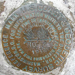
FENWICK ISLAND (HU0377)
FENWICK ISLAND
Not Found as of August 31, 2003
Spatial/elevation data
| Coordinates | N 38.4513° W 75.054449° |
| Elevation | 8.32 ft. |
| Location | Delaware
Sussex County Assawoman Bay Quad |
Mark description
| Type | Triangulation Station Disk |
| Setting | Square Concrete Monument |
| Monumented | 1932 by NGS |
| Description (NGS) | NGS Datasheet |
Narrative and photographs
I was unsuccessful at recovering this triangulation station disk. According to the coordinates, it is located beneath a mobile home along 146th Street, just a block from the lighthouse. The base of the mobile home is surrounded by a skirt and wooden deck, making access to the mark difficult if not impossible at this time.
| Designation | Status | Condition | Image |
|---|---|---|---|
| BOUNDARY MON INITIAL DE MD | Recovered | Good |
|