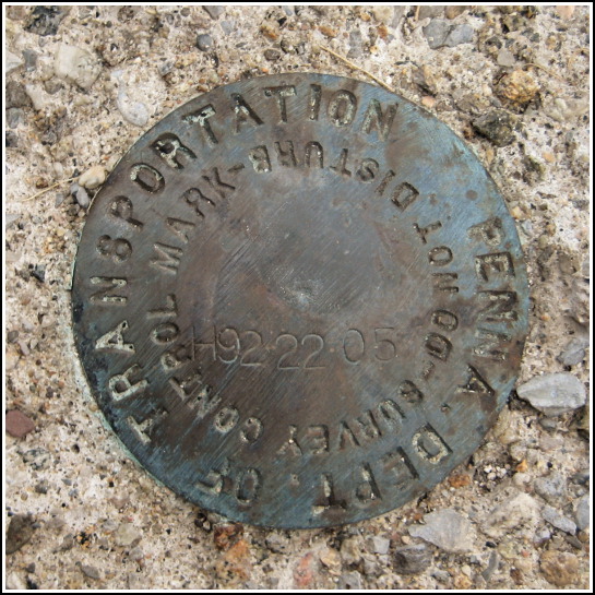
H92-22-05 (29005 ECC)
H92-22-05 (29005 ECC)
Spatial/elevation data
| Coordinates | N 41.395883° W 75.638866° |
| Elevation | 1151.70 ft. |
| Location | Pennsylvania
Lackawanna County Scranton Quad |
Mark description
| Type | Survey Control Mark |
| Setting | Stone Walk |
| Monumented | 1992 by PennDOT |
| Description (PennDOT) | Please see: 29005ECC.pdf. |
Narrative and photographs
I originally found this mark more than four years ago. I had just started working at the University of Scranton, and I occasionally brought my lunch or supper to this overlook to get away from the library and eat in peace. I was devising a puzzle-type geocache at the time (which unfortunately never came to be) and exploring the overlook when I came across this disk. I’m almost certain that I had taken photos of it at that time, but perhaps not; I cannot locate them, in any case.
Just about two weeks ago, I came across PennDOT’s Non-Spatial Benchmarks site. To my surprise, the mark at the overlook is listed, complete with a datasheet! I had to return and document this mark.
Even this wasn’t without challenges. Last week, while taking his mother to an appointment nearby, Rich passed the overlook while it was being freshly paved. He said that the area was a mess, and he wouldn’t be at all surprised if the mark were somehow disturbed or obscured. I had a feeling the mark would be safe because of its location in the stone “turret” off to the side of the actual paved parking area, but when it comes to the city of Scranton one can never be sure. I was relieved when I arrived tonight at the overlook, on a much-needed break from a crazy night at work, to discover the mark was untouched. It appears to be in good condition, if slightly scuffed.


