GHEAD
GHEAD
Spatial/elevation data
| Coordinates | N 44.328383° W 68.178798° |
| Elevation | 153.812 ft. |
| Location | Maine
Hancock County Seal Harbor Quad |
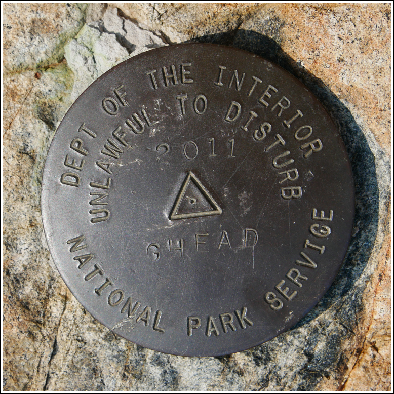
Mark description
| Type | Triangulation Station Disk |
| Setting | Bedrock |
| Monumented | 2011 by National Park Service |
| Description (National Park Service) | The mark is a 3 1/2 inch brass disk with a 2 1/4 inch flanged stem set in a drill hole in bedrock with hydraulic cement. The mark is accessed by entering Acadia National Park (fee) and following the signs for Sand Beach off of the Park Loop Road. Park in the lot and walk east across Sand Beach to find the trail head. The fee can be avoided (longer hike) by accessing the trail via Schooner Head Road. The mark is part of the NPS-URI network of backbone monuments for Acadia National Park. See: Shared Solution for GHEAD |
Narrative and photographs
Rich and I first learned about this mark almost a year ago, and we were so excited to look for it! Not only is it on Great Head, where we were married, but it was set in 2011, the year we were married. Like several other marks around the island, it’s part of a series set in 2011 by the University of Rhode Island and the National Park Service, as part of a “backbone survey” of the park.
We arrived at Sand Beach after a morning spent on the Great Meadow and Jesup Paths, having walked all the way from town to Sieur de Monts. It was still foggy at Sand Beach, believe it or not, although it had been clear for hours everywhere else. The beach was very busy today, as you would expect from a warm, gorgeous Saturday. We crossed the beach and headed up, up, up the bluffs toward the Great Head survey marker.
There were so many people climbing up that it took some time and some maneuvering to take some people-free photos. The survey mark was an easy find, in good condition, and again, a perfect symbolic mark for me and Rich!


