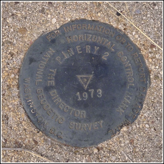
PINERY 2 (CY1152)
PINERY 2
Spatial/elevation data
| Coordinates | N 32.007477° W 109.439625° |
| Elevation | 5023.1 ft. |
| Location | Arizona
Cochise County Bowie Mtn South Quad |
Mark description
| Type | Triangulation Station Disk |
| Setting | Round Concrete Monument |
| Monumented | 1973 by NGS |
| Description (NGS) | NGS Datasheet |
NGS recovery information
Descriptive text
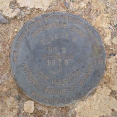
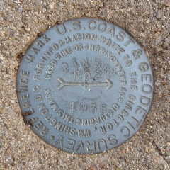
The station mark and reference marks 2 and 3 were recovered in good condition. There is a Cochise County Surveyor witness post and sign at the station. RM 4 was searched for but not found. Handheld GPS coordinates for RM 2 are 32 00 26.8(N) 109 26 22.8(W). Handheld GPS coordinates for RM 3 are 32 00 27.2(N) 109 26 22.9(W).Narrative and photographs
Today’s hike in one of our favorite places, Chiricahua National Monument, was an unusual experience due to the enormous wildfires burning just to the east, along the Arizona/New Mexico border. Thick haze filled the sky and we could smell the smoke, in varying degrees depending on how the wind was blowing, all day.
On the way back to Tucson from Chiricahua, we stopped to look for PINERY 2. It’s a roadside tri-station, so we figured it would be an easy find, and it was—mostly. The station and two reference marks (2 and 3) were easily spotted, but we could not find RM 4. I thought I saw something that resembled concrete concealed inside a tough shrub, so I called Rich to come and help investigate. As we approached the spot from a different angle I could see that it had been an illusion, simply some spider webs on top of dirt that somehow looked like concrete when the sun hit them. Together Rich and I searched the entire hillside using compass, GPS and benchmark hunters’ intuition, but never found the remaining reference mark. (We did spot some bonus ADOT marks at the corner of the fence.)
The station and reference marks 2 and 3 are in good condition along a fenceline northeast of the intersection of Arizona Routes 181 and 186. Note that RM 2 remains from the original establishment of PINERY, so its designation is simply PINERY RM 2. Reference mark 3 was established along with PINERY 2, so its designation is PINERY 2 RM 3. The station is marked by a witness post indicating a Cochise County Geodetic Control Point.


| Designation | Status | Condition | Image |
|---|---|---|---|
| PINERY 2 RM 3 | Recovered | Good |
|
| PINERY 2 RM 4 | Not Found | Unknown (Not Found) |

|
| PINERY RM 2 | Recovered | Good |
|