4330
4330
Spatial/elevation data
| Coordinates | N 32.347833° W 109.84445° |
| Elevation | 4330.207 ft. |
| Location | Arizona
Cochise County Willcox North Quad |
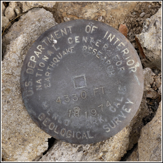
Mark description
| Type | Earthquake Research Disk |
| Setting | Rock Outcrop |
| Monumented | 1974 by USGS |
| Description (USGS) | Willcox, (at overpass of Ft. Grant Rd. at I-Hwy. 10), 0.1 mi N. of, thence 5.8 mi NNE. along Circle I Rd.; 0.1 mi E. of rd.; set in solid rock outcrop; USGS National Earthquake Research tablet stamped “4330 1974” |
Narrative and photographs
A few months ago I was idly looking through USGS datasheets, as I usually do before a trip. When I noticed that there was an “Earthquake Research Station” at the base of the western slope of the “W” mountain in Willcox, I’m sure I let out an audible whoop! These stations must be rare; I’ve certainly never heard of one before. We had to put it on our itinerary for the day of our trip to Chiricahua National Monument. The plan was to locate and document the mark, which didn’t look like it would take very long, and then move on to Chiricahua.
When we arrived at the site we found two large municipal water towers on the lower slope, one of which we would have to pass in order to get to the mark’s location. A man was working at the tower and we were a bit hesitant at first that he would even allow us access to the site, but he was very friendly and interested in our quest. He didn’t know anything about the mark, but he had no problem with us poking around looking for it.
For over 45 minutes we searched this rocky moonlike landscape, and to our great surprise, found nothing. Based on past experience, we were looking for a nice, solid, probably smooth ledge. Even a small solid ledge or outcrop would be stable enough to hold the mark. But nothing! I even checked the south side of the road leading up to the second tower, and I found a rock with what appeared to be bedrock mortars! That was an exciting archaeological find, but it sure wasn’t the USGS mark we were looking for.
I was just about to call of the search so we could head toward Chiricahua when Rich spotted the disk a measly 17 feet from the coordinates. It was just lying on the ground in a chunk of broken up concrete. Apparently it had never even been drilled into the rock! We took photos and coordinates so we could report it as destroyed. Rich knocked the remaining piece of concrete off the mark, and we took it, since the station is no longer of any use.


