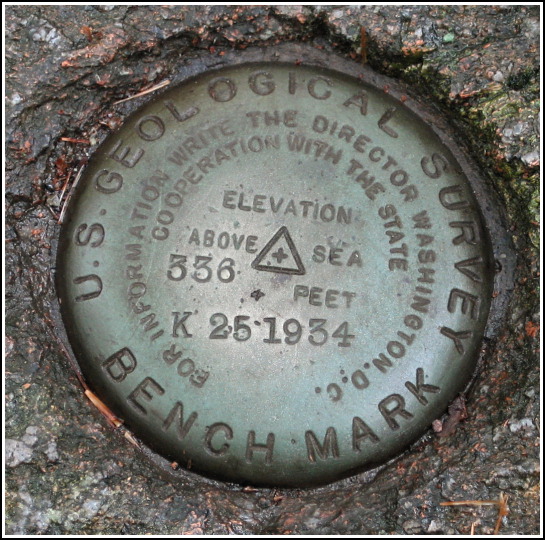
K 25
K 25
Spatial/elevation data
| Coordinates | N 44.34995° W 68.240616° |
| Elevation | 336.452 ft. |
| Location | Maine
Hancock County Seal Harbor Quad |
Mark description
| Type | Bench Mark Disk |
| Setting | Rock Outcrop |
| Monumented | 1934 by USGS |
| Description (USGS) | Seal Harbor Post Office, 4.8 mi. N. of, along Mountain Road; near N. end of Bubble Pond; in ledge; 40 ft. E. of outlet to pond; 40 ft. NW. of rd.; standard tablet stamped “K 25 1934” |
Narrative and photographs
At some point while we lunched at Jordan Pond House, I recalled that there was supposed to be a USGS benchmark near an outlet to Jordan Pond—or so I thought. I was only half right. When we pulled out the datasheet, we saw that the benchmark was, according to the description, near the outlet to Bubble Pond instead.
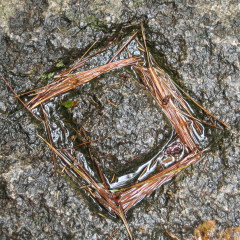
We entered the woods near Bubble Pond and quickly spotted a little stone and wood dam across the outlet, another neat artifact that we would never have seen if we hadn’t been seeking a mark. Carved into the stone dam was a distinct chiseled square, made all the more evident by the bright orange pine needles that had fallen into its recessed areas. This chiseled square is the reference mark for K 25.
After plenty of confusion and searching, Rich finally located the disk, and we spent the next half hour in the humid woods taking photos and just enjoying the colorful and peaceful scenery. The disk is in excellent condition and is set into a stone ledge near the outlet just north of Bubble Pond.


| Designation | Status | Condition | Image |
|---|---|---|---|
| K 25 RM | Recovered | Good |
|