BM DUNMORE RESERVOIR 3
BM DUNMORE RESERVOIR 3
Spatial/elevation data
| Coordinates | N 41.419066° W 75.543133° |
| Elevation | 2021.16 ft. |
| Location | Pennsylvania
Lackawanna County Scranton Quad |
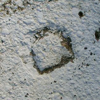
Mark description
| Type | Chiseled Square |
| Setting | Concrete Spillway |
| Monumented | Unknown by PennDOT |
| Description (PennDOT) | (1999): The station is a chiseled square in the top (near center) North end of the West concrete spillway of the Dunmore Reservoir #3. |
Narrative and photographs
On a sloppy but warm Friday Rich and I took a short hike to the reservoirs. Just a few weeks ago I found a website listing some PennDOT survey marks, and we noticed a line that begins at the reservoir and follows the trails and gravity railroad bed down to ROAR 2 in Dunmore. I was anxious to see what we could find. Rich was familiar with the area but didn’t remember seeing a concrete spillway near the coordinates. We spent some time searching the woods near the coordinates just in case, but there was no spillway or other concrete structures to be found. The coordinates listed on PennDOT’s datasheet are at the west end of the north wall of Reservoir #3, while the mark is actually located on the spillway at the west edge of the reservoir. We walked further and eventually found the mark, recorded coordinates and documented it with photos. The chiseled mark may be much older than PennDOT’s established date of 1999. The square has been painted over quite some time ago.


