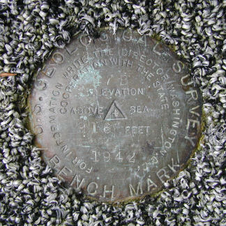
47 B
Recovered in Good Condition on September 21, 2004
Spatial/elevation data
| Coordinates | N 41.423933° W 75.77875° |
| Elevation | 916.403 ft. |
| Location | Pennsylvania
Lackawanna County Pittston Quad |
Mark description
| Type | Bench Mark Disk |
| Setting | Concrete Step |
| Monumented | 1942 by USGS |
| Description (USGS) | Milwaukee, in village of; about 250 ft E. of forks of rd. SE. to Taylor; 40 ft S. of center of rd.; in W. end of first concrete step of main entrance to Methodist Church; standard tablet stamped “47 B 1942 916”. Elev. 916.403 ft. Reference mark; 190 ft W. of tablet; on SE. corner of concrete bridge; chiseled square. Elev. 907.86 ft. |
USGS recovery information
View reportNarrative and photographs
After my successful search for the nearby disk 46 B, I drove directly to the Milwaukee United Methodist Church to see what might remain of this one. As I approached the church steps, my heart sank. The steps were covered with new gray outdoor carpeting. I assumed that the disk would still be in place underneath, but I wasn’t about to tear up the carpet. Luckily, I didn’t have to! A hole was cut in the carpeting to allow the disk to show through. It was encouraging to see that someone realized and respected the value of the mark, and went through some extra effort to ensure that it was accessible. The reference mark was not found; a bridge still exists at this location, but it is new.


