46 B
46 B
Spatial/elevation data
| Coordinates | N 41.453533° W 75.78305° |
| Elevation | 1065.948 ft. |
| Location | Pennsylvania
Lackawanna County Pittston Quad |
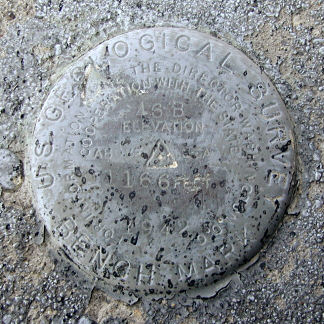
Mark description
| Type | Bench Mark Disk |
| Setting | Concrete Step |
| Monumented | 1942 by USGS |
| Description (USGS) | Newton Center, 0.4mi NE. of, along State Highway 629; at Newton-Ransom High School; 220 ft W. of center of hwy,; on SW side of new school building; in top of concrete step to basement entrance of school; standard tablet stamped “46 B 1942 1166”. Elev. 1165.948 ft. Reference mark; 122 ft nearly S. of tablet; on N. corner of concrete doorstep to basement entrance of old school building; chiseled square. Elev. 1162.41 ft. |
USGS recovery information
View reportNarrative and photographs
I couldn’t resist searching for a few local benchmarks this beautiful, sunny Tuesday morning. I was in Clarks Summit on other business anyway, and thought it would be nice to take a little trip out into the “country.” I’ve been to the old high school in the past, and I’ve driven by the church many times, without any idea that benchmarks were so close by. The disk at the old school (now the Newton Recreation Center) is located on the top step of a set of concrete stairs leading down to a basement door on the southwest side of the school building. It has been painted over. Interestingly, the mark has likely been used since being painted over. I noticed that the layer of paint was, at some point, rubbed off the designation and date to make them more legible. I searched for the reference mark, a chiseled square described to be 122 feet south of the disk-which would place it approximately in the area of a newly-constructed concrete wheelchair ramp. If there was ever another basement entrance south of the mark, it is now gone. Just to be sure, I checked the other remaining basement entrance, just northwest of the set of stairs holding the disk, but found no evidence of a chiseled square on the concrete doorstep or anywhere else on the structure.


