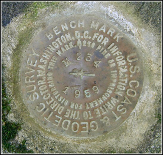
M 234 (LY1179)
M 234
Spatial/elevation data
| Coordinates | N 41.334933° W 75.287216° |
| Elevation | 1649.94 ft. |
| Location | Pennsylvania
Pike County Newfoundland Quad |
Mark description
| Type | Bench Mark Disk |
| Setting | Boulder |
| Monumented | 1959 by NGS |
| Description (NGS) | NGS Datasheet |
NGS recovery information
Descriptive text
Station mark recovered in good condition. The mark is located on Delaware State Forest land, directly across Beaver Dam Road (T 389) from a gated woods road and trailhead (Beaver Dam Trail, marker 120). It is set in a boulder as described, approximately 34 feet west of the centerline of Beaver Dam Road. Autonomous (non-corrected) handheld GPS coordinates for the station are 41 20 5.76(N) 075 17 13.98(W).Narrative and photographs
Our recovery of tri-station PINE was followed by the search for this mark, which is located just across Beaver Dam Road from the trail we took to approach PINE. We spotted the right boulder from the road and walked directly to the mark, which was exposed and in good condition. The description is accurate except that Beaver Dam Road is T 389 rather than T 380.


Recovered in good condition.
This second order vertical control station was found as described. The historical directions are still usable, except that the road is T-389 (not T-380) and is named Beaver Dam Road. The station is directly across from a gated woods road and a trailhead (Beaver Dam Trail, marker #120) on Delaware State Forest land. At the station a Garmin GPSmap76 receiver with remote active antenna was used to record autonomous (non-corrected) coordinates which were roughly 107.6 feet from the scaled coordinates listed in the NGS datasheet. The mark is well exposed, in good condition, and the stamped designation is legible.
~Rich in NEPA~


