35 ETL
35 ETL
Note Entered on May 28, 2018
Spatial/elevation data
| Coordinates | N 41.591689° W 75.554483° (estimate) |
| Elevation | 1558.646 ft. |
| Location | Pennsylvania
Lackawanna County Carbondale Quad |
Mark description
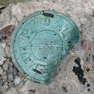
| Type | Bench Mark Disk |
| Setting | Boulder |
| Monumented | 1942 by USGS |
| Description (USGS) | Finch Hill; 1.4 mi SE. of Baptist Church, along U. S. Highway 106, thence 0.8 mi SW. along dirt rd. about 3.0 mi in airline NW. of Carbondale; 99 ft E. of center of grass triangle at forks of rd. NW.; 85 ft NE. of powerline pole 654; in field; in boulder; standard tablet stamped “35 ETL 1942” Reference mark; 195 ft W. of tablet; on NE. headwall of bridge; Pennsylvania Department of Highways standard disk (1561.838 ft) |
Narrative and photographs
This area still resembles the description closely, and there’s a very good chance the mark is still in place. There is even still a utility pole in the proper location, although it now has a different number. The grass in the field was very high today, and we couldn’t spot a boulder (it probably doesn’t project much, if at all, above the surface of the ground), so in the interest of avoiding ticks we decided to come back and search in the winter. I’m kicking myself that I didn’t realize that the reference mark is a PDH disk on a nearby bridge! We will definitely have to look for that disk soon.
| Designation | Status | Condition | Image |
|---|---|---|---|
| PDH | Recovered | Poor |
|