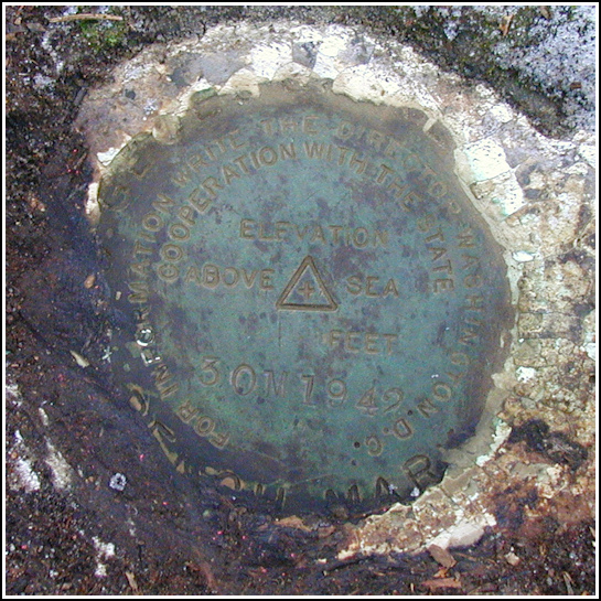
30 M
30 M
Spatial/elevation data
| Coordinates | N 41.657717° W 75.303517° |
| Elevation | 1381.677 ft. |
| Location | Pennsylvania
Wayne County Honesdale Quad |
Mark description
| Type | Bench Mark Disk |
| Setting | Boulder |
| Monumented | 1942 by USGS |
| Description (USGS) | Tanners Falls, 0.6 mi SW. of; 65 ft N. of Y-rd. fork; 30 ft NW. of N. end of stone wall; 30 ft NW. of rd.; 60 ft SE. of wire fence; in boulder; standard tablet stamped “30 M 1942”. Elev. 1381.677 ft. Reference mark; 165 ft SW. of tablet; 10 ft NW. of rd.; 10 ft SE. of wire fence; on boulder; chiseled square. Elev. 1388.40 ft. |
USGS recovery information
View reportNarrative and photographs
A day of hunting, geocaching and benchmarking wouldn’t be complete without getting lost at least once along the way! All the map data we had available told us that Killroe Road would be a straight shot through the woods from Route 670 to Tanners Falls. Well, it’s not. The road is closed just northeast of the last house on Killroe Road, coming from Route 670. We first discovered this when trying to get to the Tanners’ Condos geocache, but somehow forgot (or confused ourselves) when trying to navigate back through the falls area toward this mark. We ended up following Egypt Road northwest all the way out to Route 670 and then coming back in on Killroe Road to the Y-intersection and the mark. The stone wall and wire fence still exist, and like 29 M, trees surrounding the boulder were blazed, making for an easy find. This disk is in good condition. We did not search for the reference mark at this time.

