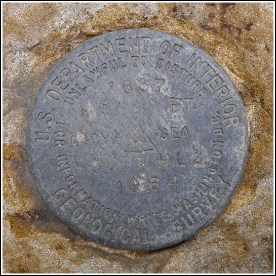
3 HLZ
3 HLZ
Spatial/elevation data
| Coordinates | N 41.45998° W 75.46991° |
| Elevation | 1636.862 ft. |
| Location | Pennsylvania
Lackawanna County Lake Ariel Quad |
Mark description
| Type | Bench Mark Disk |
| Setting | Stone Culvert |
| Monumented | 1964 by USGS |
| Description (USGS) | Cortez, 0.9 mi SW. of, along state hwy.; 27 ft W. of, and 0.5 ft higher than centerline of rd. at field rd. E.; in N. end of 4-ft rock culvert; standard tablet stamped “3 HLZ 1964 1637” |
Narrative and photographs
Our second find on our way to a Fourth of July picnic was 3 HLZ, a USGS mark that we somehow never looked for before. It was an easy find on an old rock culvert over a tiny stream along Cortez Road. The disk is in very good condition, although the rock culvert wasn’t quite what I expected. It is made of what appear to be separate granite blocks; it doesn’t give the typical appearance of stability. There is no sign that the block has been moved, but it would be hard to determine this. We didn’t notice it at the time, but it appears from the photograph that there might be a chiseled square on the adjacent block. If so, it may have been used as a reference mark, but it is not mentioned on the datasheet. There are three aspects of the description that don’t quite match up. The culvert actually runs east-west, so the disk is on the east end, not the north end. The culvert is longer than 4 feet. We couldn’t find any sign of the “field rd. E” mentioned in the description, nor any indication of it on the historical aerial images from PennPilot.


