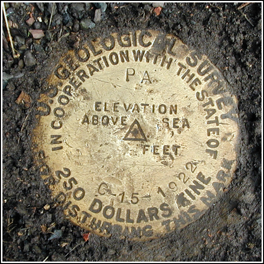
15 C
15 C
Spatial/elevation data
| Coordinates | N 41.22267° W 75.54773° |
| Elevation | 1624.197 ft. |
| Location | Pennsylvania
Lackawanna County Stoddartsville Quad |
Mark description
| Type | Bench Mark Disk |
| Setting | Rock Outcrop |
| Monumented | 1922 by USGS |
| Description (USGS) | Clifton; 140 ft N. of former RR. station; 50 ft. W. of rd. fork; between rd. and RR. tracks; in rock outcrop; standard tablet stamped “15 C 1922 PA” |
USGS recovery information
View reportNarrative and photographs
On a mid-July day too hot and much too humid to do anything but drive around in an air-conditioned car, Rich and I decided to check out the southern portion of the railbed near Clifton. (We had biked the northern part in May, exploring the Boar Hole and finding 39 JPN along the way.) I was hoping the southern half of the railbed would offer the same kind of scenic riding and easy approaches to the several benchmarks along its route. We couldn’t tell from the maps how accessible this portion would be nor how it would cross the Lehigh River, so we resolved to check out the area first by car and then come back with the bikes if possible.
We easily found the point in Clifton at which the railbed intersected State Route 2013 from the northwest. While searching the other side of the road to find the point where the railbed picked up again, Rich noticed a witness post with a sign. Interesting! We figured there must have been a disk within a few yards, but were unable to find it at first. I finally uncovered it while digging around in the dirt with my shoe. When I saw the stamping I realized this must be BM1624, a mark I’ve looked at several times on the map and datasheet. I was planning to save it for our ride along this portion of the railbed and didn’t even have the information with me today. Well, I’ll take ‘em when and where I find ‘em!
This end of the railbed didn’t look promising as it cuts through someone’s driveway and yard and beneath their house before disappearing into the woods again. We decided to drive on and explore a few other possible access points, none of which were viable until we reached Bradys Lake. We took a brief hike/trespass through a grassy path on a Christmas tree farm, where I found a small bush of huge, sweet, probably cultivated blueberries.


