RGH 24
RGH 24
Spatial/elevation data
| Coordinates | N 41.408666° W 75.583366° |
| Elevation | 1646.62 ft. |
| Location | Pennsylvania
Lackawanna County Olyphant Quad |
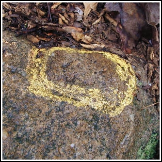
Mark description
| Type | Chiseled Square |
| Setting | Boulder |
| Monumented | 1997 by PennDOT |
| Description (PennDOT) | To reach bench mark RGH 22 from the intersection of Rt. 348 and Rt. 247 in Mt. Cobb, follow Rt. 247 north for 2.7 km (1.71 mi) to a power line crossing. Turn left onto the power line and go approximately 100 m to a dirt trail on the right. Turn right onto the trail and proceed, passing an overflow and dyke at 1.3 km (0.8 mi), and another at 2.1 km (1.3 mi), to the intersection with an old railroad bed at 5.6 km (3.5 mi). Follow the railroad bed south-west for 0.24 km (0.15 mi) to the bench mark on the right. Please see: RGH 24. |
Narrative and photographs
RGH 24 was so close to RGH 18 I couldn’t resist going for it even though we didn’t have much time left this morning to explore. In addition, it allowed us to make a nice loop on our way back to the car, and—bonus!—there are some stone ruins near the mark that I hadn’t yet seen. Stone relics from the old gravity railroad can still be found along the trails on this mountain.
We were tricked a bit by the datasheet diagram and the vegetation growing over the boulder, but after a few minutes of searching we found the right boulder and the chiseled square on its highest point. After documenting it and examining the stone ruins further down the trail, it was time to leave. I was glad Rich had a chance to take this trail also, as he mentioned it’s been years since he hiked here. A little bit of unexpected woodchuck hunting on the way back to the car made the day complete. The blueberries are almost ready!


