MEHOOPANY RM 2
Spatial/elevation data
| Coordinates | N 41.5139° W 76.070466° |
| Elevation | Unknown |
| Location | Pennsylvania
Wyoming County Meshoppen Quad |
Mark description
| Type | Landmark/Intersection Station |
| Setting | Tower |
| Monumented | 1929 by NGS |
| Description (NGS) | NGS Datasheet |
NGS recovery information
Descriptive text
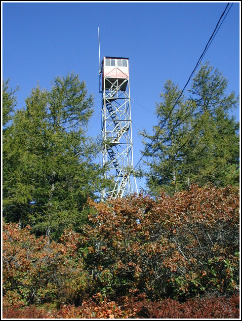
The tower was found in good condition. As noted in the 1976 recovery note for LZ1844, reference mark no. 2 for triangulation station Mehoopany 1929 has been removed from beneath the tower.Narrative and photographs
For more information about this reference mark, see its parent mark MEHOOPANY.
This mid-October day was warm and beautiful for a hike, so Rich and I decided to tackle the stations on the summit of Mehoopany Mountain. We were disapointed to find that the station disk for LZ1844, triangulation station MEHOOPANY, has been pried out of its setting and removed (it has since been determined to be Destroyed by NGS). The fire tower was found in good condition. There is some confusion over the fire tower’s designation, since both it and the second reference mark disk for station MEHOOPANY are referred to as “MEHOOPANY RM 2”. A contact at NGS examined the old paper records and gave essentially the same explanation that Rich provided.

Station found as described.
This second order horizontal control station is situated at the summit of Mehoopany Mountain, south of Mehoopany. From Russell Hill northwest of Tunkhannock and the intersection of Rt. 6 (N41° 35.165’ W076° 0.258’), follow Rt. 87 south for roughly 4.85 miles to the town of Mehoopany (N41° 33.814’ W076° 3.649’), then left onto Sugar Hollow Road (SR3003) for roughly 1.2 miles (N41° 33.231’ W076° 3.441’), then right onto T454 for 0.6 miles, straight on T437 for roughly 0.1 miles (N41° 32.835’ W076° 3.778’), and finally left onto Fire Tower Road (T440) south for 2.85 miles. Fire Tower Road is a packed dirt/gravel access road that is mostly in very good condition leading directly to the summit and the lookout tower.
LY1845 (MEHOOPANY RM2) refers to the lookout tower, and reference mark MEHOOPANY No. 2 for triangulation station MEHOOPANY (LZ1844) appears to have been the original disk set in a boulder directly beneath the tower. The boulder and mark were later removed and the top center of the tower’s cabin was designated as RM2. It also appears that at this time their coordinates were deemed to be identical. ~Rich in NEPA~

