MEHOOPANY (LZ1844)
MEHOOPANY
Spatial/elevation data
| Coordinates | N 41.51405° W 76.070516° |
| Elevation | 2365 ft. |
| Location | Pennsylvania
Wyoming County Meshoppen Quad |
Mark description
| Type | Triangulation Station Disk |
| Setting | Boulder |
| Monumented | 1929 by NGS |
| Description (NGS) | NGS Datasheet |
NGS recovery information
Descriptive text
Recovered in destroyed condition.Narrative and photographs
Continuing our tour of Tunkhannock area tri-stations, on this beautiful fall day Rich and I set out to find MEHOOPANY. I’d actually been in the area on the Fourth of July and had driven halfway to the top, but a sudden thunderstorm erupted and I decided to turn back. This time I drove my VW almost all the way up, and we hiked the remaining distance to the summit. The fire road was in fair condition and was likely driveable the entire way, but I didn’t want to take unnecessary risks.
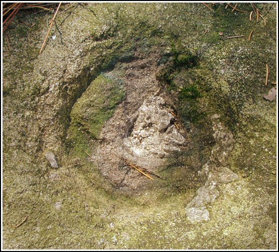
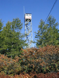
Once at the top, we realized we were not alone on the mountain. Some workers were busy on the communications towers, just south of the clearing near the lookout tower where we set up shop. They worked the entire afternoon and I believe were still on the premises when we left, and they caused us no trouble. Rich and I walked right up to the small boulder which once held the station mark, but unfortunately the entire mark was missing. The round impression and evidence of the stem remain. We then took measurements from the existing chain-link fence around the lookout tower as it is not clear whether the original “building” mentioned in the description is the one that stands today, and in any case the building and tower are not accessible due to the fence. The station is approximately 20 feet northwest of the north corner of this fence.
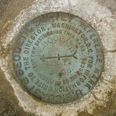
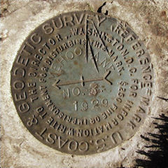
We located RM 1 with ease. It is in excellent condition and is set in a flat boulder projecting approximately 12 inches as described. RM 1 was found to be 59 feet northeast of the east corner of the chain-link fence. RM 3 required a more thorough search but was eventually found on a boulder hidden deep in thick scrub oak just southeast of powerline pole 5F36. It is in good condition except for three deep cuts across one quarter of the face of the disk. Interestingly, the “3” appears to have been stamped or carved over another number which was previously obliterated. We spent a good deal of time trying to sort out the details of RM 2 and the mysterious “RM 1 RESET” which appears on the official datasheet’s box score but is nowhere mentioned in the recovery text. We measured and searched at the given distance and bearing but found nothing. We later submitted our question to Dave Doyle at NGS, who replied with the following:
RM 1 Reset comes from data submitted to Coast & Geodetic Survey (now NGS) in 1968 as part of a mapping project. Unfortunately, the 1968 recovery note they submitted did not specifically describe RM 1, but the distance they provided was sufficiently different from existing measurements to force us to preserve the value and ‘create’ a reset RM. Unfortunately, these data were submitted to us about 15 years after the project was completed, so there was no ability to go back to the original field team for clarification.
After reviewing our documentation, including photographs, NGS marked this station officially Destroyed in the database.


Recovered in poor condition.
This first order triangulation station is situated at the summit of Mehoopany Mountain, south of Mehoopany. From Russell Hill northwest of Tunkhannock and the intersection of Rt. 6 (N41° 35.165’ W076° 0.258’), follow Rt. 87 south for roughly 4.85 miles to the town of Mehoopany (N41° 33.814’ W076° 3.649’), then left onto Sugar Hollow Road (SR3003) for roughly 1.2 miles (N41° 33.231’ W076° 3.441’), then right onto T454 for 0.6 miles, straight on T437 for roughly 0.1 miles (N41° 32.835’ W076° 3.778’), and finally left onto Fire Tower Road (T440) south for 2.85 miles. Fire Tower Road is a packed dirt/gravel access road that is mostly in very good condition leading directly to the summit, the lookout tower, and the station. Once at the summit the historical description leads reliably to the station and the two reference marks.
The station was located and identified but the marker has been removed. All that remains is the impression of the drill hole in top center of the small outcropping boulder. The boulder is 20 feet northwest of the north corner of the chainlink fence surrounding the lookout tower.
RM1 is set in a flat outcropping boulder projecting about 1 foot above grade and is well exposed. It is 59 feet northeast of the east corner of the chainlink fence surrounding the lookout tower. RM3 is well exposed, set in the center of a large outcropping boulder projecting about 1 foot above grade, and situated within a dense patch of scrub oak and laurel near powerpole number 5F36.
There is some confusion regarding the NGS datasheet box score and a reference to MEHOOPANY RM1 RESET, which was searched for but not found. No mention of this mark is made in any of the historical descriptions. Secondly, LY1845 (MEHOOPANY RM2) refers to the lookout tower, and MEHOOPANY RM2 appears to have been the original disk set in a boulder directly beneath the tower. The boulder and mark were later removed and the top center of the tower’s cabin was designated as RM2. It also appears that at this time their coordinates were deemed to be identical.
At the station a Garmin GPSmap76 receiver with active remote antenna was used to record autonomous (non-corrected) coordinates which were 4.6 feet from the adjusted coordinates listed on the NGS datasheet. The two reference marks are in very good condition and the stamped designations are clearly legible. It’s a shame that the station mark was vandalized since NGS will most likely declare this station destroyed. ~Rich in NEPA~ Note: NGS has subsequently declared this station as destroyed based on a recovery report submitted by Zhanna.


| Designation | Status | Condition | Image |
|---|---|---|---|
| MEHOOPANY RM 1 | Recovered | Good |
|
| MEHOOPANY RM 2 | Recovered | Good |
|
| MEHOOPANY RM 3 | Recovered | Good |
|