TT 9 K
TT 9 K
Spatial/elevation data
| Coordinates | N 41.83412° W 75.87726° |
| Elevation | 1669.837 ft. |
| Location | Pennsylvania
Susquehanna County Montrose West Quad |
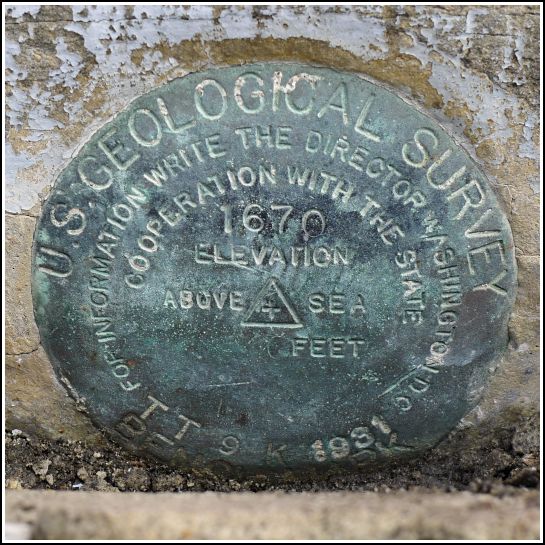
Mark description
| Type | Transit Traverse Station Disk |
| Setting | Stone Foundation |
| Monumented | 1931 by USGS |
| Description (USGS) | Montrose; in S. face of foundation stone of E. pillar to middle arch at main entrance to Susquehanna County Courthouse; standard tablet stamped “TT 9 K 1931 1670” |
Narrative and photographs
My father invited us to join him this morning for a drive to Montrose for the annual Blueberry Festival and a breakfast of fresh blueberry pancakes. This was an offer too good to pass up! I haven’t been to the blueberry festival in years, but I always thought it was fun. As a bonus, I discovered that there was supposedly a bench mark set into the courthouse foundation. Of course, after the pancakes were eaten (and after a blueberry pie, cactus pup, and Susquehanna County history book were purchased), finding the bench mark became our priority.
As we approached the brick columns at the courthouse’s main entrance, I began to have my doubts. I saw nothing on the brick surface, and according to the description the mark should be set into the “foundation stone” of the pillar, which did not seem to be visible. Once we drew closer, though, we could see the top of the disk just poking above the surface of the stone step. Part of the step is actually cut out to allow access to the disk! The disk is in good condition and seems well protected against damage, if perhaps difficult to use.
We searched for the chiseled cross on the SE end of the bottom step that once served as a reference mark, but we found nothing. It seems likely that the steps were replaced or resurfaced since the mark’s placement.

 entrance of the Susquehanna County Courthouse.")


