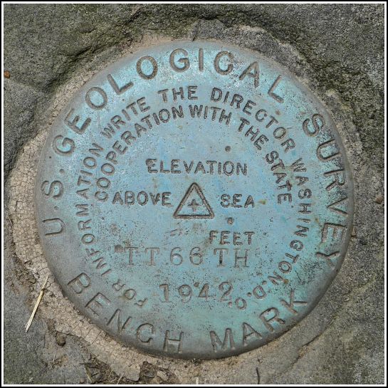
TT 66 TH
Spatial/elevation data
| Coordinates | N 41.68098° W 75.73778° |
| Elevation | 1200.600 ft. |
| Location | Pennsylvania
Susquehanna County Lenoxville Quad |
Mark description
| Type | Transit Traverse Station Disk |
| Setting | Boulder |
| Monumented | 1942 by USGS |
| Description (USGS) | Glenwood, 2.0 mi NW. of, on Lenox township rd. 416; 27 ft S. and 15 ft W. from junction of second class rd. W., through barn lot of P. S. McAleen; in sandstone boulder flush with ground; standard tablet stamped “TT 66 TH 1942” |
Narrative and photographs
Today had already been an exciting day. We enjoyed a pancake breakfast at the Montrose Blueberry Festival (and a find of TT 9 K on the courthouse there), and a cool and scenic hike at Salt Springs State Park. And now another bench mark find too?
This was actually our second attempt to find TT 66 TH. The first was back in January, on our “Susquehanna County Sojourn” with dad. At that time, the ground and any boulders therein were snow-covered, and because the coordinates place us in the yard between two homes, we didn’t feel comfortable scraping or digging or otherwise attempting to remove snow.
Today, several boulders/outcrops were obvious, and it took only a few seconds to spot the disk on one of them very near the road. Nevertheless, Dad and I knocked at both houses to explain our intent, but no one was home. We quickly checked the mark and took our photos. The disk is in very good condition and the outcrop seems solid and undamaged.
The names of the current property owners were not visible anywhere that we could see, but the address is 1969 Glenwood Road. The datasheet lists the property owner as P.S. McAleen in 1942. We suspect this may be a misspelling of McAloon (in fact, this is what initially sparked my interest in this mark, since my family knows many of the McAloons in the area). Dad said that he always knew this as the Francioni residence.

.")
