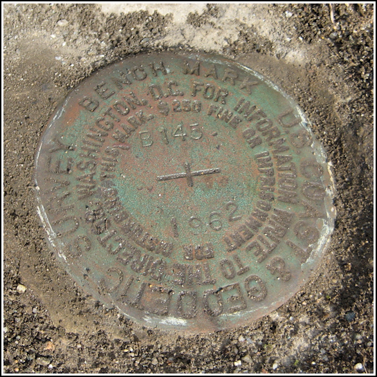
B 145 (PE0302)
B 145
Spatial/elevation data
| Coordinates | N 44.274° W 68.325361° |
| Elevation | 59.60 ft. |
| Location | Maine
Hancock County Southwest Harbor Quad |
Mark description
| Type | Bench Mark Disk |
| Setting | Rock Outcrop |
| Monumented | 1962 by NGS |
| Description (NGS) | NGS Datasheet |
NGS recovery information
Descriptive text
Recovered in good condition in rock garden. Handheld GPS coordinates for the bench mark are 44 16 26.4(N) 068 19 31.3(W).Narrative and photographs
While in Southwest Harbor a few days ago, Rich parked near the general vicinity of the datasheet coordinates and I took a quick look for this mark—but I was at least a hundred feet too far south and failed to find anything I would consider to be a rock garden. Of course, once Rich swung the car around and we headed north again, I spotted the obvious rock garden adjacent to a small cottage. We planned on returning to complete the search.
Today’s hike with Dave and family at Beech Mountain put us in the vicinity of this mark again, and this time we had some luck. Fortunately, too, the brief rain shower that we encountered on our way to Southwest Harbor let up as soon as we reached the cottage, which appears to be a rental property. The mark was buried, which I had not suspected, beneath two years’ worth of accumulated grit and pine debris and even some moss. Rich helped me uncover it despite my fear that we were being much too conspicuous. No one bothered us, and we were soon on our way after documenting the mark and leaving it clear for the next surveyor to use. It’s also a neat addition to this rock garden, surrounded by tiny hens & chicks and a variety of mosses and lichens. The mark appears to be in good condition and is solid in its setting.


