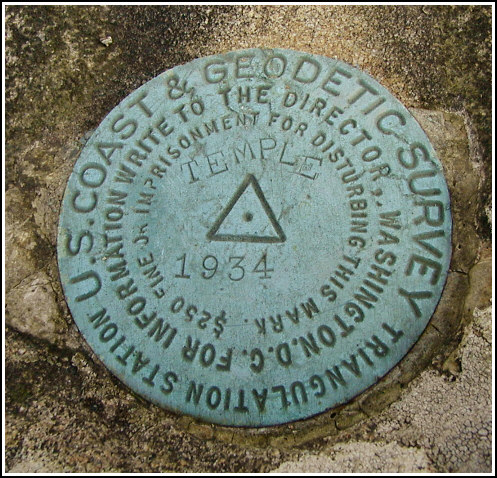
TEMPLE (LZ1890)
TEMPLE
Spatial/elevation data
| Coordinates | N 41.22095° W 76.044266° |
| Elevation | 1430 ft. |
| Location | Pennsylvania
Luzerne County Nanticoke Quad |
Mark description
| Type | Triangulation Station Disk |
| Setting | Boulder |
| Monumented | 1934 by NGS |
| Description (NGS) | NGS Datasheet |
NGS recovery information
Descriptive text
The station mark and reference marks 1 and 2 were recovered in good condition. The cemetery is named Edgehill Cemetery. A dim trail begins approximately 30 yards north-northwest from a headstone marked “Anderson”. Follow this trail north through a steep trough and then northwest to the saddle east of the station, then head west (off trail) to the summit and the station.Narrative and photographs
The historic description was enough to lead Rich and me to the cemetery, but from there we had to find our own route. We saw the Tubbs tomb right away, and we found what is likely the stump of the 18-inch tree. However, no trail was visible just beyond the tree. It appears that the northwest boundary of the cemetery has been extended somewhat and that the trail is no longer accessible from this point as it was in 1958.
We hiked up into the open woods and made our way over to the station, climbing a steep slope, descending to the saddle between the hills and then climbing again west to our goal. The marks were well exposed and therefore easy to see even from a distance, and they are all in good condition. Some scraps of white plastic sheeting were found near the station, possibly remnants of the spot being marked for aerial surveys.
While we photographed the marks, a man who claimed to own the property approached us. Although we had not encountered signs during our hike, he said that the area was posted; but he did not mind our being there for the purpose of recovering the marks. We ate a snack while resting at this sunny spot overlooking Nanticoke, and I took a little nap on a lush moss carpet nearby. On our way back to the cemetery, we did find a dim road that may have been part of the intended route to the station. We followed it southeast from the saddle and then south down an extreme slope to emerge again in the cemetery.

.")
Recovered in good condition.
This first order triangulation station is situated on the southeast side of a prominent wooded knoll roughly 0.6 miles west-northwest of Edgehill Cemetery and 1.6 miles west of West Nanticoke. The 1934 and 1958 “to reach” directions are still fairly usable, however the northwest edge of the cemetery appears to have been expanded in recent years. A dim woods trail leading to a saddle below the station can be accessed by going roughly 25-30 yards north-northwest from a large headstone marked with the name Anderson. The trail leads north through a steep trough and turns abruptly northwest. A handheld GPS receiver was helpful in pinpointing the location of the station.
The station and its two reference marks were found as described. At the station a Garmin GPSmap76 receiver with active remote antenna was used to record WAAS-corrected coordinates which were identical to the adjusted coordinates listed on the NGS datasheet. All three marks are well exposed, in good condition, and the stamped designations are legible. ~Rich in NEPA~


.")
| Designation | Status | Condition | Image |
|---|---|---|---|
| TEMPLE RM 1 | Recovered | Good |
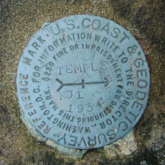
|
| TEMPLE RM 2 | Recovered | Good |
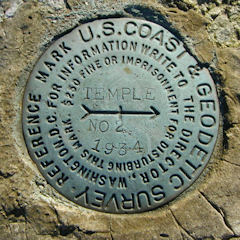
|