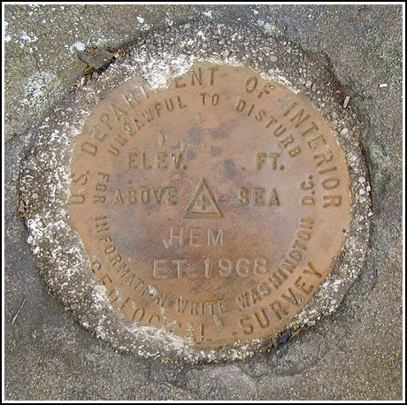
HEM ET (LZ1875)
HEM ET
Spatial/elevation data
| Coordinates | N 41.384566° W 76.11275° |
| Elevation | 2116 ft. |
| Location | Pennsylvania
Wyoming County Noxen Quad |
Mark description
| Type | Electronic Traverse Station Disk |
| Setting | Rock Outcrop |
| Monumented | 1968 by USGS |
| Description (NGS) | NGS Datasheet |
NGS recovery information
Descriptive text
The station and reference marks 1 and 2 were recovered in good condition. The station is approximately 6 feet west-northwest of the remains of the rock cairn, 14 feet north of a 12 inch diameter oak tree, and 9 feet south-southwest of a 5 inch diameter maple tree. The witness signs no longer exist. The azimuth mark was not observed from the station.USGS recovery information
View reportNarrative and photographs
Triangulation station HEM ET was an easy find, but it still required a steep hike that was sufficient to warm us up on this chilly autumn day. After a small miscalculation that landed us on the wrong woods road and led to the grounds of a hunting club, we retraced our steps and found a much better access point to North Mountain. We encountered several hunters while hiking the woods road, but after turning onto the trail along the ridge to approach the station, we were alone. The marks were all easy to locate, well exposed and mostly in accordance with the 1968 description. On our way back to Rich’s vehicle we stopped at a high point on the woods road where we could see across the valley. We spotted several towers, including one that may have been the Harvey Fire Tower (the azimuth mark), though we couldn’t be sure at the time.


Recovered in good condition.
This second order triangulation station is situated at the north end of the ridgeline of North Mountain in Noxen Township, northwest of Harveys Lake, and just north of the Wyoming/Luzerne County border.
To reach from Pikes Creek and the intersection of Rt. 118, follow Rt. 29 north for roughly 4.1 miles, then left onto Sorber Mtn. Road (T677) for roughly 1.3 miles, bear left at the Y fork and continue on Sorber Mtn. Road for 0.65 miles (N41° 22.561’ W076° 06.126’), then left onto T762 for 0.45 miles to a gate across the start of a dirt/gravel woods road (N41° 22.864’ W076° 06.310’), then west-southwesterly on the switchbacking woods road for 0.6 miles to the ridge (N41° 22.762’ W076° 06.751’), and finally north along a dim trail for 0.4 miles to a small knoll and the station on the left. A handheld GPSr made locating the station an easy task. For the most part, the historical description leads fairly reliably to the station and the two reference marks. There is a locked gate at the start of the dirt woods road leading up the mountain. The road is steep, rocky and rutted but can be accessed with a high ground clearance 4WD vehicle. The dim trail north along the ridgeline is obstructed by numerous deadfalls.
The station mark is well exposed, set in the top center of a flat outcropping boulder nearly flush with the ground. It is 14 feet north of a 12-inch diameter oak tree, 9 feet south-southwest of a 5-inch diameter maple tree, and 6 feet west-northwest of the remains of the rock cairn (which has been reconfigured as a deer hunter’s seat). The two oak trees and witness signs referred to in the historical description no longer exist.
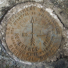
RM1 is well exposed, set in an outcropping boulder projecting about 1.5 foot above grade. The oak tree and witness sign referred to in the historical description no long exists.
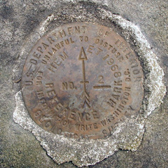
RM2 is well exposed, set in an outcropping boulder projecting about 1 foot above grade. The oak tree and witness sign referred to in the historical description no long exists.
At the station a Garmin GPSmap76 receiver with active remote antenna was used to record WAAS-corrected coordinates which were identical to the adjusted coordinates listed on the NGS datasheet. All marks are in very good condition and the stamped designations are clearly legible. ~Rich in NEPA~


| Designation | Status | Condition | Image |
|---|---|---|---|
| HEM ET RM 1 | Recovered | Good |
|
| HEM ET RM 2 | Recovered | Good |
|