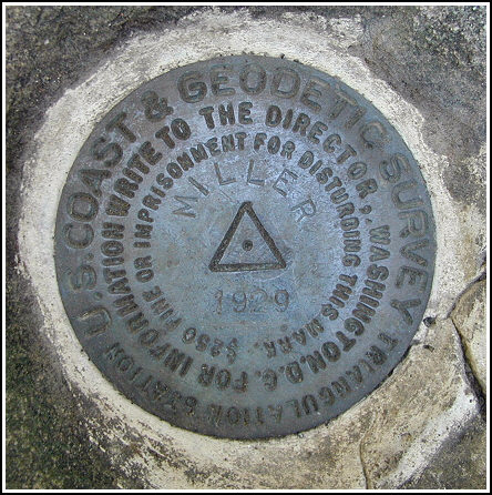
MILLER (LY2775)
MILLER
Spatial/elevation data
| Coordinates | N 41.48915° W 75.952116° |
| Elevation | 2215 ft. |
| Location | Pennsylvania
Wyoming County Center Moreland Quad |
Mark description
| Type | Triangulation Station Disk |
| Setting | Boulder |
| Monumented | 1929 by NGS |
| Description (NGS) | NGS Datasheet |
NGS recovery information
Descriptive text
The station mark and reference marks 1 and 2 were recovered in good condition. The pine trees were not identified, and the 16-foot pole signal no longer exists. New route description follows. To reach the station from the intersection of Routes 6 and 29 in Tunkhannock, follow Route 29 S for approximately 4 miles to a road left. Turn left and follow Jenks Road for approximately 0.15 miles to a gravel drive and gated woods road on the left. Follow the woods road east-northeast, climbing for 2.1 miles to an open area and an intersection with a trail running north-south. Turn right and pack south on the trail for 0.41 miles to the station on the right.Narrative and photographs
This mark intrigued me because the trails and roads I saw on the topo map didn’t correlate with those on the aerial photograph. As we approached the area on Route 29 (not Route 92) we looked for the roads indicated in the description, but found no clue to where they might once have been even though they appeared on our maps. We tried any means to get close, eventually traveling up a long, winding road till I was willing to take my VW no further through the mud and ruts.
Upon turning around to head back down the hill, we were intercepted by a farmer who repeatedly inquired “Can I help you?” After explaining our mission and while sitting patiently through 20 minutes of old hunting and roaming stories from back in the day, we did extract some valuable information. We learned that the property on the mountain is now part of the DeNaples empire, and that we could park at a gate down the hill for access to the summit.
We parked in the indicated spot, crossed a pretty stream and small waterfall, and emerged on a woods road that passes some run-down hunting cabins and eventually deteriorates to no path at all. We then bushwhacked up a steep slope and emerged on another woods road, wide and easily traveled, that winds to the top. We followed it directly to a clearing, where we headed south on the north-south path that intersects the road. The station was approximately 30 feet into the woods on our right after hiking less than half a mile on this trail. We fought our way through the dense growth and easily spotted the disk on its boulder, framed by pine branches.
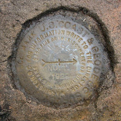
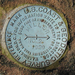
More difficult to locate was RM1. We searched and measured and found a suspicious-looking rock in the right location, but digging through the fallen branches, roots, soil, and reddish stone that broke off in our hands produced nothing but confusion. We put aside RM1 for a few moments and switched our focus to RM2. This proved to be a great confidence booster as we located it within minutes. It is set as described on a large boulder approximately 40 feet north of the station.
Determined to find RM1, we returned to the suspicious rock and continued the excavation. Finally, beneath layers of crumbling rock, we found the mark solid in its setting in the flat boulder. It seems likely that this very unusual arrangement occurred naturally, though we’ve never before seen anything like it.
After a lunch of pies and peanuts, we took our photos and notes and then headed back down the mountain. As we approached my car we realized that we could have avoided bushwhacking altogether if we had just gone a few feet further north to find the main woods road instead of turning onto the first road we encountered. While leaving the area, we discovered that the main woods road does in fact intersect Jenks Road, the main paved road in the area, near an old home and a trailer. The woods road is protected by a locked gate but is otherwise driveable to the top in a vehicle with proper clearance.


Recovered in good condition.
This first order triangulation station is situated at the summit of Miller Mountain, south of Tunkhannock. The 1929 historical description errs when referring to Rt. 92 south. Updated “to reach” directions are as follows. From Tunkhannock at the intersection of Rt. 6 take Rt. 29 south for 4.0 miles, turn left onto Jenks Road (N41° 29.617’ W075° 59.291’) following it along and to the right for roughly 0.16 miles, then left onto a gravel drive between a mobile home and an old abandoned house for roughly 130 feet to a gate (painted black) across the beginning of a woods road (N41° 29.529’ W075° 59.199’). The woods road for the most part is passable with a high ground clearance vehicle. It is a steady climb for 2.1 miles to an open area where a north-south trail intersects (N41° 29.638’ W075° 57.084’). Turn right onto the narrower trail heading due south for 0.41 miles and the station off the trail to the right (west). A handheld GPS receiver made locating the station an easy task.
Note: the gate off Jenks Road is locked. A local resident informed us that DeNaples now owns the property on the mountain. For this recovery the final approach along the woods road was made on foot from a slightly different parking spot on the other side of a stream that parallels the woods road just to the south. It was 5 miles round trip.
Once at the summit the historical description leads reliably to the station and the two reference marks, although RM1 had to be measured out precisely and required considerable excavation to uncover. The 16-foot signal pole above the station no longer exists, and no signs of it were found. The large boulder in which the station is set is roughly 30 feet west of the trail and easy to locate.
RM1 is west of the station set in the top of a large flat reddish boulder at or slightly below ground level and was obscured by an accumulation of dead tree limbs, a thick layer of loam, laurel roots, and numerous flakes of rock which appear to have been layers in the boulder that had been infiltrated by roots, water and soil and forced apart over the years. The mark does not appear to have been deliberately covered this way, and no mention is made on the datasheet. The small evergreen referenced in the historical description is now a pair of large white pines.
RM2 is set in the top of a large boulder and is well exposed. It is north of the station and roughly 30 feet west of the trail, surrounded by dense brush and laurel.
At the station a Garmin GPSmap76 receiver with active remote antenna was used to record WAAS-corrected coordinates which were 6.1 feet from the adjusted coordinates listed on the NGS datasheet. The station mark and RM2 are in very good condition and the stamped designations are clearly legible. RM1 is in good condition and the stamped designations are legible upon close inspection. ~Rich in NEPA~


| Designation | Status | Condition | Image |
|---|---|---|---|
| MILLER RM 1 | Recovered | Good |
|
| MILLER RM 2 | Recovered | Good |
|