P 49 (LZ0099)
P 49
Spatial/elevation data
| Coordinates | N 41.391266° W 76.27555° |
| Elevation | 2052.81 ft. |
| Location | Pennsylvania
Wyoming County Lopez Quad |
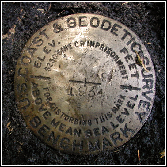
Mark description
| Type | Bench Mark Disk |
| Setting | Bridge Abutment |
| Monumented | 1934 by USGS |
| Description (NGS) | NGS Datasheet |
NGS recovery information
Descriptive text
Recovered in good condition.Narrative and photographs
On our second visit to the former community of Ricketts, we finally unearthed this benchmark. Using the map provided by Mike Burnside for his historical multicache Downtown Ricketts, we navigated to the southernmost railroad bridge and from there, through the trees, we spotted the stone abutments we were aiming for. Reaching our goal was more difficult. We fought through plenty of vines, thorns, scrub and poison ivy to reach the north abutment; of course, according to the description I felt sure the benchmark had to be located on the south abutment. The saner member of our team stayed behind while I waded through Mehoopany Creek and climbed the wildly overgrown south abutment. After turning over a thick layer of mud and moss on the western end, I found the disk. It’s in very good condition and the designation and date are clearly legible. The mark is located not on the very top of the abutment (the part with sloping sides), but on the level several feet below it. The description of the route to the station may be accurate, but I didn’t check it. If this route is still passable, it would probably make for an easier walk.
Note: this benchmark is in Wyoming County, not in Sullivan County as the Geocaching page and the original datasheet claim. I had the datasheet changed to reflect the correct county.


