TUNKHANNOCK PENELEC ANT POLE (LY2800)
TUNKHANNOCK PENELEC ANT POLE
Spatial/elevation data
| Coordinates | N 41.534566° W 75.899583° |
| Elevation | 1883 ft. |
| Location | Pennsylvania
Wyoming County Tunkhannock Quad |
Mark description
| Type | Landmark/Intersection Station |
| Setting | Antenna Pole |
| Monumented | 1968 by NGS |
| Description (NGS) | NGS Datasheet |
NGS recovery information
Descriptive text
Recovered in destroyed condition.Narrative and photographs
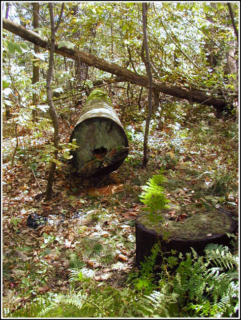
This pole was found on a cold, snowy day atop Osterhout Mountain, just after our recovery of triangulation station OSTER. The following information was submitted to NGS:
We found what we believe to be the Pennsylvania Electric Company antenna mast sawed off several inches from the ground and with the upper portion of the pole lying nearby. It’s a wooden pole approximately 20 inches in diameter at the base. Conduit straps and porcelain insulators can be found along the length of the pole, but there are no identifying numbers or other marks. The pole is directly adjacent to a metal equipment shed. WAAS-corrected coordinates obtained at the base were approximately 6.1 feet from the coordinates listed on the datasheet.
NGS has marked this station officially Destroyed.

Station landmark no longer exists.
This station was located and identified but the station landmark was destroyed. The wooden antenna pole has been sawed off about 1 foot above grade and is laying on the ground nearby. There is a Penelec equipment shed next to the base of the pole (station). At the station a Garmin GPSmap76 receiver with active remote antenna was used to record WAAS-corrected coordinates which were 6.1 feet from the adjusted coordinates listed on the NGS datasheet (shed obscured a full view of sky). ~Rich in NEPA~


