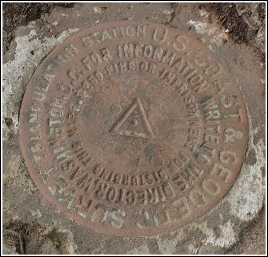
LENOX (LY2796)
LENOX
Spatial/elevation data
| Coordinates | N 41.70418° W 75.6759° |
| Elevation | 1185 ft. |
| Location | Pennsylvania
Susquehanna County Lenoxville Quad |
Mark description
| Type | Triangulation Station Disk |
| Setting | Rock Outcrop |
| Monumented | 1959 by NGS |
| Description (NGS) | NGS Datasheet |
NGS recovery information
Descriptive text
The station and both reference marks were recovered in good condition. The blazed tree was not found. To reach the station from Exit 211 (Lenox Exit) on Interstate 81, travel northwesterly along PA Route 106 approximately 0.25 miles to a four-way intersection. Turn left onto PA Route 92 and continue south 0.56 miles to crossroads (Milford and Owego Turnpike Rd.). Follow track road westerly, uphill, 0.36 miles to a four-way intersection, bear right and continue 0.03 miles to a fork, then bear right and continue 0.12 miles. Station is 128 ft. on right (east), on a wooded slope. The station disk is set in a rock outcrop slightly below the level of the ground. Reference mark 1 is set in a well exposed outcrop and is roughly 38 inches higher than the station. Handheld GPS WAAS-corrected coordinates for RM 1 are 41 42 14.9(N) 075 40 33.5(W). Reference mark 2 is set in a rock outcrop slightly below the level of the ground and is roughly 25 inches higher than the station. Autonomous (non-corrected) handheld GPS coordinates for RM 2 are 41 42 15.2(N) 075 40 33.4(W).Narrative and photographs
28 October 2007
Today, as part of the activities for our “Sunday morning benchmark club,” Rich and I began our hunt for LENOX. We parked at the intersection of Route 92 and the dirt road we had discovered the week before (which, we later learned, has the amusing name of “the Milford and Owego Turnpike”) and headed west, following a jeep trail up a steep, rocky hill. Watching the GPS as we walked, we could see that we were basically circling the mark at a radius of 0.14 miles. Finally, after taking two right forks, the distance between us and the mark began to decrease. We passed evidence of several small quarries near the summit: slabs of squared-off stone were stacked alongside the trail, and we found some pits cut into the hillside. After walking one half mile, we emerged from the woods to a clearing at the summit, where we saw before us a small wooden shack that Rich presumed to be used to dry wood. The GPSr indicated that the station was still further east, about 128 feet down a wooded slope. I could see immediately that we would have a challenge on our hands!
Initially, we saw no marks and no rock outcrops matching the description. A cursory overview of the area was a complete failure, even though we felt confident in the coordinates. What does this mean? Usually, it means we’re going to have to dig. While I poked around looking for the station disk, Rich spotted RM1 on an outcrop higher on the slope. The outcrop was well exposed, though it projected less than the three feet stated in the description. This was yet another clue that we would need to dig to find the station.
We spent near thirty minutes measuring from the reference mark and tracking coordinates on the GPSr in an attempt to find the station disk or even catch a glimpse of an outcrop in which it may have been set. We were simultaneously trying to determine the location of RM 2, which eluded us as well. It was obvious that some errors existed in the description; because of the configuration of the marks on the slope, it is not possible that RM 2 is higher above the station than RM 1. This further added to our confusion, but we decided to trust the box score and worry about the other details later.
We scraped off rocks, threw off larger stones, and Rich dug through several inches of rooty, rocky soil in both areas without any luck. Eventually I spotted an outcrop that seemed to be in the right spot for RM 2. We needed to uncover about three feet of the outcrop in order to work our way back to the mark, which was also several inches below the surface. Rich did a great job, and we shared a big high-five when we finally uncovered the mark from beneath the mud and pine debris. Now there was just one more disk to find—the station, which is usually the easiest.
With both reference marks found, pinpointing the station should be a simple task of intersecting the two vectors from the reference marks. But even this sure-fire procedure failed to reveal the station immediately! Rich continued to dig and remove stones, even though we had searched that area before. We actually had the station uncovered before we realized it—it was still hidden by a thin layer of dirt, and it took us a few minutes more of head-scratching before we cleaned off the outcrop completely and Rich spotted the mark hiding there.
This was a tough but thrilling recovery. In the process we found a new place to hike, discovered some description errors that we can fix, and lost our probe three or four times (the last time, I’m afraid, for good). We also, unfortunately, ran out of time and had to leave before we could document our recovery with photos and coordinates. We vowed to purchase a new probe (and mark it with pink flagging tape), a small level, and pink marking paint—and to come back the following Sunday, all of which we did.
4 November 2007
The steep uphill hike felt easier this week, and the half-mile to the summit passed by in a blur of benchmark-related conversation, brisk winds and dull orange foliage surrounding us. All three marks were in good condition, just as we had left them, and required just a little brushing off for photographs. Before bringing out the camera, though, we put our new level to good use to determine the actual height differences between the station and each reference mark, since the NGS description is in error. Without a cord, which had been left at home accidentally, we had to hook the level onto our long measuring tape instead and stretch the tape from each reference mark, one at a time, horizontally toward the station. We then measured the vertical distance by extending our thin steel tape down to the station disk. This worked quite well, and we determined that RM 1 is about 38 inches higher than the station (not 12 inches as stated in the description) and that RM 2 is about 25 inches higher than the station (rather than 14 inches). I took my photos while Rich sprayed circles of pink paint around them and on the small, flat rocks that he used to cover the marks. Hopefully this will help any future surveyors who need to use this station!


| Designation | Status | Condition | Image |
|---|---|---|---|
| LENOX RM 1 | Recovered | Good |
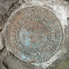
|
| LENOX RM 2 | Recovered | Good |
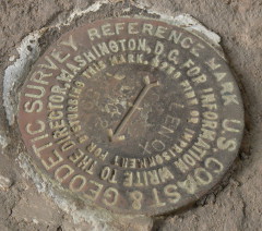
|