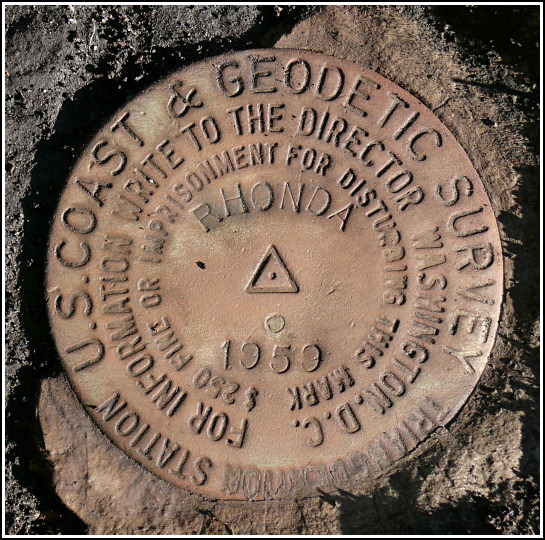
RHONDA (LY2791)
RHONDA
Spatial/elevation data
| Coordinates | N 41.551823° W 75.637717° |
| Elevation | 1682 ft. |
| Location | Pennsylvania
Lackawanna County Dalton Quad |
Mark description
| Type | Triangulation Station Disk |
| Setting | Boulder |
| Monumented | 1959 by NGS |
| Description (NGS) | NGS Datasheet |
NGS recovery information
Descriptive text
The station and both reference marks were recovered in good condition. The witness post is gone. To reach the station from Exit 199 (Scott Exit) on Interstate 81, travel east on Route 524 approximately 0.15 miles to a T-intersection. Turn left and travel north 0.08 miles to a road right (Scott Road). Turn right and travel southeast 0.8 miles to a road left and sign Wemberly Hills Golf Course. Turn left and follow road 0.3 miles to clubhouse and parking area. Park and walk 0.2 miles northeast along unpaved road/driveway. Turn left into a field and walk approximately 50 yards to the station. Handheld GPS WAAS-corrected coordinates for RM 1 are 41 33 06.5(N) 075 38 16.7(W). Handheld GPS WAAS-corrected coordinates for RM 2 are 41 33 07.3(N) 075 38 15.6(W).Narrative and photographs
Sunday morning was calm and the sun shone brightly—a rarity in northeastern Pennsylvania, even during the typically dry month of October. We parked in the golf course lot, then followed a dirt road toward the small knoll, a slight rise from the level of the road. Our tool bag and backpacks were bulging with the usual long measuring tape, trowels, gloves, probes, garden clippers, flagging tape, GPS and remote antenna, hatchet, folding saw, compass, and camera. I carried a tripod slung across my shoulder and held the datasheet in my hand. We didn’t need a map for this excursion.
The former pasture land in the vicinity of RHONDA is now a weedy meadow, but it is still mostly open and easy enough to walk through. It is bordered on the southwest by open woods and on the north by a high stone wall. We unloaded our equipment in an area free of weeds and began to look around.
At first we saw no marks and no rock outcrops matching the description. A quick overview of the area was a complete failure, even though we felt confident in the coordinates. What did this mean? Usually it means we have some digging to do. Probing the ground near the station coordinates, we could tell that a great deal of soft but root-filled soil covered the bedrock beneath. Rich pulled back a heavy mat about four inches thick and we dug and scraped, trying to reach bedrock, but nothing revealed itself to us. Hmm…perhaps this would be a tougher recovery than we had thought. To save ourselves the sweat and frustration of digging an area too large in the wrong place, we decided to search a little harder for the reference marks, hoping that they could be found and would then lead us to the station. After all, that’s their purpose!
Rich and I walked together in the general direction of RM1, having noted that RM2 was most likely near the thickly overgrown stone wall and would be harder to find. We descended a bit, almost imperceptibly, and spotted a large, flat outcropping slab of bedrock. Simultaneously, Rich and I saw the blue-green disk!
Using our sighting compass and the “box score” data about the reference marks from RHONDA’s NGS datasheet, we projected an imaginary line from RM1 back toward the station, and Rich paced off the approximate distance. Our long tape is usually handy in these situations, but in this case the arrangement of brush and a tree made it impossible to use. We still saw nothing promising in the vicinity of the mark. We stuck a probe in the ground anyway, to mark our guess at the station’s suspected location. From this estimated point, I used the compass again to direct Rich on the bearing which, according to the box score, should bring him to RM2. It was indeed hiding in the thicket, somewhere near the stone wall.
“Gardening”—our term for clearing back brush and weeds—was necessary. Rich hacked and slashed his way through, and eventually spotted the reference mark just a few feet from our bearing line. It was set in a rock that was halfway embedded in the ground beneath the stone wall. I fought my way through the remaining brush to stand over it, and I was able to sight a bearing line back toward the station. Rich intersected RM2 with the line we’d taken from RM1, and, combining this knowledge with that which we could deduce from the former placement of a witness post, we were able to pinpoint the station disk. We soon realized that our earlier efforts had very nearly uncovered the disk, but a thin coating of dirt had still somehow obscured it. A closer look and a quick brush with a gloved hand were all it took for RHONDA to emerge! We were thrilled to document our find with photos and to submit the first official NGS recovery of this station in over thirty years.
Read the full text of “Finding Rhonda” in Caching Now. (Now available on my website here: /2019/03/17/finding-rhonda)


.")
| Designation | Status | Condition | Image |
|---|---|---|---|
| RHONDA RM 1 | Recovered | Good |
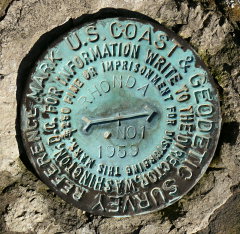
|
| RHONDA RM 2 | Recovered | Good |
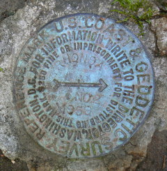
|