GREEN

Spatial/elevation data
| Coordinates | N 41.051501° W 75.783706° |
| Elevation | 1672 ft. |
| Location | Pennsylvania
Luzerne County White Haven Quad |
Mark description
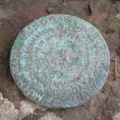
| Type | Triangulation Station Disk |
| Setting | Square Concrete Monument |
| Monumented | 1958 by NGS |
| Description (NGS) | NGS Datasheet |
Narrative and photographs
We first learned about this station a few years ago, when I happened to notice it while browsing topo maps. It’s a short drive from “downtown” White Haven, where we usually park to ride the Lehigh Gorge Trail. Although Green Mountain was once the property of a hospital (in the 1940s) and then a school for the mentally challenged (in the 1950s, when the station was set), it now belongs to the Holy Protection Monastery. What fun, we thought—surely the kindly monks will allow us to hike to the top of the knoll. We didn’t know at the time that the monastery is actually for women, who are nuns rather than monks.
Today, after a long ride along the Lehigh Gorge trail, we went to the monastery to look for GREEN. Our luck? We had “nun.” I guess we should have attempted it a few years ago while the place was still under construction/renovation, but Rich wasn’t up for the hike back then.
The monastery has come a long way since the last time we were there. We marveled at the buildings roofed in bright Spanish tile and the whole layout of the property. I felt like I was in the southwest or on a Greek isle somewhere. After we passed the main building, we could see what looked like a clearing, possibly leading to a trail heading up the mountain, but there were signs in Greek and English saying that it was private and to pass required a special blessing.
We found a young sister coming up behind us and we asked what we would need to do if we wanted to hike up the mountain toward the cross. She said she could not give us permission but that she would go inside and ask someone else. After a few minutes she came out and said that she was sorry, but she couldn’t get permission for us. We thanked her, she blessed us—apparently not the special blessing—and we left soon after. (We later joked between ourselves that it was Rich’s fault because the nuns must have his poster on the wall from back when he was a bad kid in Catholic school. I know they’re not the same kind of nuns, but we still got a laugh out of it.)
Next we set off toward the azimuth mark, on the other side of the river and south about a mile. The road was narrow, which concerned us a bit, but when we neared the coordinates we saw a convenient clearing along the western side of the road and, as luck would have it, a 9x5 foot boulder across and about 12 feet above the road, as described. Unfortunately, there were houses just beyond. I decided I would walk up the driveway, which would give me an easy view of the top of the boulder as I passed by. If I could see the mark and if I felt relatively secluded, I might just go ahead and take my photos and coordinates; otherwise, I would knock on the door of the residence to ask for permission.
As I hiked up the gravel driveway, I heard a dog barking. Shit. I went a little further and saw a man working on his truck. I got a hillbilly rocker vibe from his long curly beard and lack of front teeth, but he turned out to be one of the nicest people I’ve met while benchmark hunting. He assured me that the dog was harmless (it did seem quite docile), and he asked where I was headed, assuming I was lost. I explained that I was actually there to document the survey mark on the big boulder alongside his driveway. He was thrilled to find out what the mark’s purpose was, having known about it for years (he said, in fact, that his grandfather would have been living there when the mark was set in 1958). I explained what an azimuth mark was used for and how it related to the GREEN triangulation station. He even got to hear the story of how we were denied the special blessing at the monastery. “Yeah, they’re weird up there,” he said about the nuns.
We still intend to attempt to reach the station and reference marks in some way, either via the powerline or pipeline cut that appears to approach the summit from Old Route 940, or from one of the old Jeep trails wrapping around the back side of the mountain. Depending on how close the marks are to the cross, it may still be difficult to access them. (And we’ll have to be on the lookout for nuns all the while!)
| Designation | Status | Condition | Image |
|---|---|---|---|
| GREEN AZ MK | Recovered | Good |
|
| GREEN RM 1 | Note Entered | Unknown (Not Found) |

|
| GREEN RM 2 | Note Entered | Unknown (Not Found) |
|