PIMPLE HILL RESET (LY2736)
PIMPLE HILL RESET
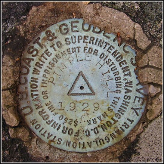
Spatial/elevation data
| Coordinates | N 41.026771° W 75.504749° |
| Elevation | 2211 ft. |
| Location | Pennsylvania
Monroe County Blakeslee Quad |
Mark description
| Type | Triangulation Station Disk |
| Setting | Boulder |
| Monumented | 1929 by NGS |
| Description (NGS) | NGS Datasheet |
NGS recovery information
Descriptive text
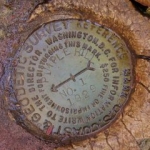
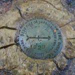
The station mark and reference marks 1 and 2 were recovered in good condition. The to-reach as given in the 1969 recovery is adequate. Pimple Hill is located on Delaware State Forest land. Handheld GPS coordinates for RM 1 are 41 01 36.4(N) 075 30 16.2(W). Handheld GPS coordinates for RM 2 are 41 01 35.8(N) 075 30 17.1(W).Narrative and photographs
Found it soon after the no-find at the nearby Conglomerate Rocks cache (we found out later that it was missing). The 1969 description was accurate and the disk was very easy to spot. It is in very good condition. I had other plans for the afternoon and didn’t want to spend too much time looking for the reference markers; I took a quick look but didn’t see them. I plan to come back on Thursday and search much more thoroughly!
(Note from October 31, 2002:)
Rich and I came back to Pimple Hill today to find the restored Conglomerate Rocks cache, and afterward we decided to hunt for the reference marks (in the snow). What fun it was! (Someone’s going to wonder why the snow is scraped off all the 2’ x 6’ boulders in the area.) Rich unearthed RM2 pretty easily; it was on a boulder I’d noticed the other day, but I hadn’t dug deep enough. RM1 was more of a problem because there was so little information provided to help us locate it. We spotted a few likely locations, but no marker. As we were about to leave (our feet were getting cold), Rich knocked the tiniest chunk of snow off some rock we’d already examined, and there it was sitting underneath! I think it was laughing at us the whole time. Well, at least we finally found the whole set, and we can sleep soundly at night.


(Recovered on October 31, 2002)
I happened to be in the area to complete a Geocache hunt with a friend and part of the plan was to find all the marks in this set. At the station mark my Garmin GPSmap76 receiver read approximately 7.6 feet from the posted coordinates. The disc was in excellent condition and legible. As Zhanna explained below, the RM2 reference mark was buried under a mat of moss, dirt and fine roots. The disc is in very good condition and the designation is legible. Reference mark RM1 was extremely difficult to locate due to the inadequacy of directions in the historic descriptions. It might have been a lot easier to find it without the snow and leaf cover since this disc was well exposed in the surface of the rock. It is in very good condition and legible. When hunting benchmarks I feel obliged to find all the marks in the set, and this was one of the hardest sets I’ve done to date. Hopefully, the photos and GPS coordinates logged here will be helpful to other benchmark enthusiasts. ~Rich in NEPA~


| Designation | Status | Condition | Image |
|---|---|---|---|
| PIMPLE HILL RM 1 | Recovered | Good |
|
| PIMPLE HILL RM 2 | Recovered | Good |
|