KINGSBURY (LY2675)
KINGSBURY
Spatial/elevation data
| Coordinates | N 41.99955° W 75.361733° |
| Elevation | 1010 ft. |
| Location | Pennsylvania
Wayne County Hancock Quad |
Mark description
| Type | Boundary Monument |
| Setting | Granite Monument |
| Monumented | 1940 by NGS |
| Description (NGS) | NGS Datasheet |
NGS recovery information
Descriptive text
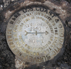
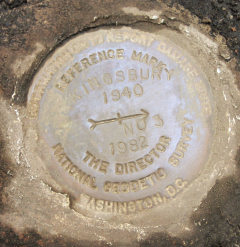
Station monument, RM 1 and RM 3 recovered in good condition. The rock outcrop into which RM 1 is set is approximately 10 feet largest dimension. RM 3 is approximately 76 feet northwest of the station, at 305 degrees magnetic. Autonomous (non-corrected) handheld GPS coordinates for RM 1 are 41 59 57.6(N) 075 21 42.7(W). Autonomous (non-corrected) handheld GPS coordinates for RM 3 are 41 59 59.5(N) 075 21 42.8(W).Narrative and photographs
Rich and I spent a few hours on this breezy, flurrying morning searching for Hmmm… with Hound (of fox-and-the-hound) and his mother, but we had no luck and eventually decided to give up on the hunt. We were cold, and we had more exciting plans for the day anyway … searching for two NY/PA boundary markers!
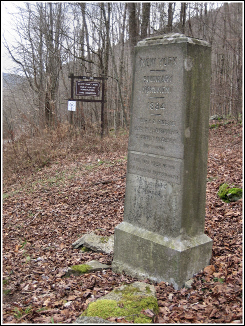
After a leisurely drive up Route 171 and a stop to investigate the Inn at Starlight Lake, we were on our way toward the boundary monument. Nearing the mark, we both sensed that we’d been in this spot before, though it wasn’t till we got home and did some research that we discovered that we’d driven right past the parking area for “Walk to the Lake,” a (now-archived) cache that we both found back in May 2002. [In fact, I believe it was the first time I beat Rich to a First Find!] The boundary monument is only about a mile from that cache, at a high spot along the river that would probably be lovely in Summer but was bare and colorless in December.
The stone boundary monument itself was no challenge to find, as it’s about six feet high and just a few yards south of the road. RM3 was partially covered by dirt and debris, but we were able to zero in on it quickly from clues in the description. Our toughest challenge was finding RM1. The description of the rock into which it’s set is misleading (probably incorrect), with the boulder described as being 1.0 ft, largest dimension. We suspected an error immediately, because the rock is also described as having a height of about 4.0 ft. Multiple times we searched the prominent outcrops of rock in the target area, and finally found RM1 beneath a thick mat of moss and soil on an outcrop approximately 10 feet long. The error in the description may have been a simple misplacing of the decimal point.


| Designation | Status | Condition | Image |
|---|---|---|---|
| KINGSBURY RM 1 | Recovered | Good |
|
| KINGSBURY RM 3 | Recovered | Good |
|