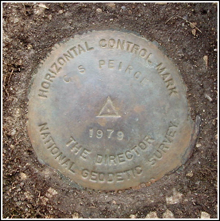
CS PEIRCE (LY2641)
CS PEIRCE
Spatial/elevation data
| Coordinates | N 41.34145° W 74.7653° |
| Elevation | 487 ft. |
| Location | Pennsylvania
Pike County Milford Quad |
Mark description
| Type | Triangulation Station Disk |
| Setting | Round Concrete Monument |
| Monumented | 1979 by NGS |
| Description (NGS) | NGS Datasheet |
NGS recovery information
Descriptive text
The station mark and reference mark 1 were recovered in good condition. Reference mark 2 was not recovered. The most northeast point of the landing has been damaged, and no evidence of a chiseled cross could be found on any other corner of the concrete landing adjacent to the house. The azimuth mark was not found. It may have been paved over.Narrative and photographs
After two successful geocache hunts this morning, Rich and I decided to try a few benchmarks in the Milford area. This one looked intriguing as it was supposed to be on the grounds of a Park Service historical house that neither of us had noticed before. We found the station mark without difficulty along the wooded northeast edge of the front lawn. Its location is indicated by an angled pipe stuck in the ground adjacent to the mark. As we were clearing the mark of debris, an NPS employee approached us to find out what we were doing. Upon learning that we were recovering the mark and not geocaching, he left us to continue our work.
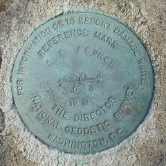
Reference mark 1 was found easily on the headwall of the culvert along the road directly in front of the house. Like the station mark it’s in good condition, and it is easily visible from a distance. Though we searched extensively, we were unable to locate the second reference mark. There was plenty of confusion over which landing might have been the one referred to, so we searched all corners of all the landings on the north and east sides of the house, and took measurements from the telephone pole as well. We found no chiseled cross. Interestingly, the corner of the landing we thought most likely to have held the mark has been damaged; it’s probable that the mark was on this corner and therefore no longer exists.
According to the datasheet the azimuth mark was located less than 1000 feet away, along Routes 6 & 209. We drove to the site after finishing our work at the Peirce house. Upon beginning our search near the powerpole, we were immediately approached by a young busybody who demanded to know what we were doing. She left and, for some unknown reason, came back to demand the same information of us a few minutes later. We mostly ignored her and continued our search, but it was certainly a curious reaction to people working in a highway right-of-way, not on private property. Unfortunately, we were unable to find any sign of the mark, even though our measurements from reference objects matched the description. It is likely that the mark still exists but is covered by a fresh layer of asphalt.
It is fitting that a triangulation station was placed on the grounds of this estate, as Peirce was a prominent geodesist with the U.S. Coast & Geodetic Survey, serving from from 1859 to 1891. He was additionally a mathematician, scientist, philosopher (founder of pragmatism) and, somewhat by necessity, a writer. In 1887 he retired, eventually becoming ill and destitute, to this Milford estate (“Arisbe”) where he died in 1914. More information on the house and Peirce himself is available at the historic site near the station mark, and at the following websites: Peirce Edition Project and Spanning the Gap.


Station and RM1 recovered in good condition.
This third order triangulation station is situated on the Charles S. Peirce estate, at the northeast edge of grounds surrounding the house. The estate is currently under the auspices of the NPS and is home to the DWGNRA Research and Resource Planning Division. The 1969 “to reach” directions are still fairly usable.
Only the station mark and RM1 were found as described. A thorough search of the landing on the most northerly side of the house was performed, the angles and distances measured from the station and the powerpole, but a chiseled cross in the concrete corner could not be located. The corner point of the landing most closely matching the historical description has apparently sustained some damage, and since the cross was definitely not seen in any other of the corners it seems likely that the mark no longer exists. The landing on the front of the house facing the highway has been resurfaced. If this is the landing being referred to, then the mark would have been covered by new concrete. It should be noted also that there is considerable confusion about the cardinal compass directions given in the description regarding the orientation of the house, landing, and entrance.
The azimuth mark was searched for and not found. The historical description leads to the appropriate powerpole, the directions and distances to the mark seem to fit, but the entire area around the suspected location appears to have been paved over since the time this mark was monumented. It’s possible the mark is still there but under a layer of asphalt. The witness post was not found, either.
At the station a Garmin GPSmap76 receiver with active remote antenna was used to record WAAS-corrected coordinates which were identical to the adjusted coordinates listed on the NGS datasheet. The station mark and sole reference mark are well exposed, in good condition, and the stamped designations are legible. ~Rich in NEPA~


| Designation | Status | Condition | Image |
|---|---|---|---|
| CS PEIRCE AZ MK | Not Found | Unknown (Not Found) |

|
| CS PEIRCE RM 1 | Recovered | Good |
|
| CS PEIRCE RM 2 | Not Found | Unknown (Not Found) |
|