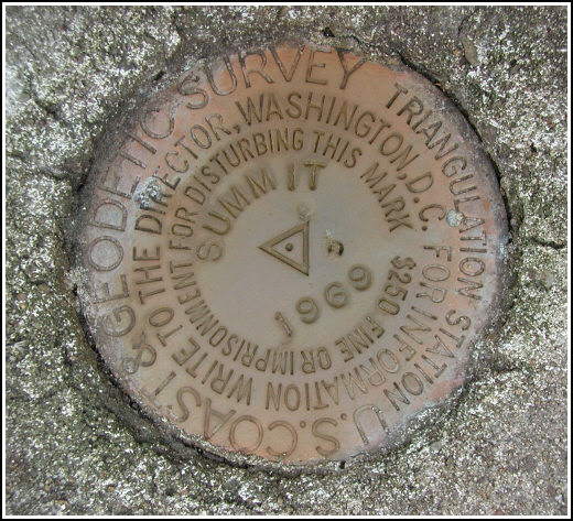
SUMMIT (KV3873)
SUMMIT
Spatial/elevation data
| Coordinates | N 40.829766° W 75.862483° |
| Elevation | 1536 ft. |
| Location | Pennsylvania
Carbon County Nesquehoning Quad |
Mark description
| Type | Triangulation Station Disk |
| Setting | Square Concrete Monument |
| Monumented | 1969 by NGS |
| Description (NGS) | NGS Datasheet |
NGS recovery information
Descriptive text
The station mark, reference marks 1 and 2 and the azimuth mark were recovered in good condition. The cross street/paved road is named East Hazard Street, the T-road is North Elm Street, and the road along the north edge of the cemetery is Treeline Drive. The field road leading north from the cemetery was not found. The witness post no longer exists.Narrative and photographs
A few times during our summer rides on the Switchback Trail, Rich and I had considered searching for this mark, but there was no opportunity better than this pleasant November day. We took an easy ride up to Summit Hill from Jim Thorpe and found the cemetery easily enough, but then the trouble started. The road running along the north edge of the cemetery—now named Treeline Drive—is undergoing construction and adjoining plots have been surveyed. The area is apparently experiencing some development. We searched several probable access points along Treeline Drive, but no trace of the woods road leading north to the station could be found. The entire area is thickly overgrown with some variety of towering weeds. We did find a small opening to an ATV track cutting back through the weeds, so we followed that through the weeds and the woods to the bottom of a steep slope, and this was as far as we felt comfortable bringing the bikes. Using hands as well as feet, we began to climb.
Once we reached the top of the bluff—no small feat as it was extremely steep and slippery and densely littered with old broken glass bottles—we found all the marks in a matter of minutes. Each mark was well exposed when we arrived and was visible from several yards away. The marks are all in excellent condition, and it didn’t take us long to finish our photographs and notes.
Afterward we picked our way back down the treacherous slope and grabbed our bikes, and then headed back south on the ATV trail toward the cemetery. Our plans to search out some of the old landmark stations in Summit Hill were rained out by a very sudden, very fierce storm which convinced us to fly back down Route 902 toward our vehicle. We arrived hilariously drenched and coated in black mud, most of which we washed off in the creek before seeking warm refuge in Rich’s car.
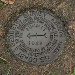
The rain, of course, stopped soon afterward and after a quick snack of candy corn, we were ready to search for the azimuth mark. We parked at the intersection of North Pine Street and North Lehigh Street and then walked east to the mark.(*) It is situated as described: southwest of the southwest corner of No. 204, adjacent to powerline pole 16484, and is set between the sidewalk and the curb. This mark was also in excellent condition.
(*) Note: there is some confusion as to the actual route of Route 902. Some maps indicate that it travels north-south not on North Pine Street but two blocks west, on North Chestnut. Our recollection is that Route 902 follows North Pine Street, but we will confirm this the next time we visit the area.


All marks recovered in good condition.
This second order triangulation station is situated on the northwest edge of a brush-covered bluff at the east end of the village of Summit Hill, 6.9 airline miles west-southwest of Jim Thorpe. The 1969 “to reach” directions are still fairly usable. The cross street and paved road referred to is now called E. Hazard St., the T-road is North Elm St., and the north edge along the cemetery is named Treeline Drive. The field road leading north at the cemetery was not found and the entire area is overgrown with dense, impenetrable vegetation. A little to the west an ATV trail was discovered along a rutted gully. Following it northerly for roughly 100 feet and then bushwhacking northeastward for another 200 feet leads to the bluff and the station at the top. The slope is precipitous, dangerously loose and strewn with old glass bottles and broken glass. A handheld GPS receiver was helpful in pinpointing the location of the station.
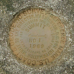
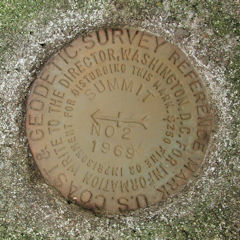
The station and its two reference marks were found as described. The metal witness post and sign no longer exists. The azimuth mark is located east of the intersection of N. Pine and E. Lehigh Streets, on the north side of E. Lehigh St. between addresses 200 and 204, in the grass strip between the sidewalk and the street curb.
At the station a Garmin GPSmap76 receiver with active remote antenna was used to record WAAS-corrected coordinates which were 6.1 feet from the adjusted coordinates listed on the NGS datasheet. All four marks are well exposed, in good condition, and the stamped designations are legible. ~Rich in NEPA~


| Designation | Status | Condition | Image |
|---|---|---|---|
| SUMMIT AZ MK | Recovered | Good |
|
| SUMMIT RM 1 | Recovered | Good |
|
| SUMMIT RM 2 | Recovered | Good |
|