F 281 (LY1599)
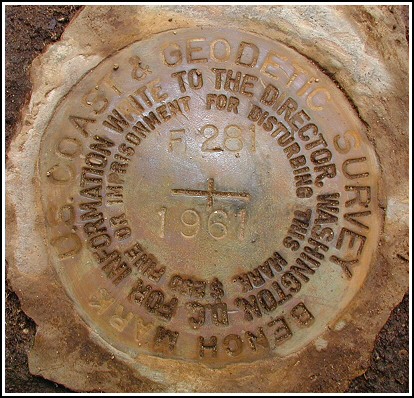
F 281
Spatial/elevation data
| Coordinates | N 41.360017° W 75.578433° |
| Elevation | 1623.20 ft. |
| Location | Pennsylvania
Lackawanna County Moscow Quad |
Mark description
| Type | Bench Mark Disk |
| Setting | Boulder |
| Monumented | 1961 by NGS |
| Description (NGS) | NGS Datasheet |
Narrative and photographs
This was another benchmark hunt by bike. Rich and I took a morning ride out along Elmhurst Boulevard and continued our search for the marks along this route. Using the historic description we zeroed in quickly on the correct boulder, but it took time to clear it of dirt and expose the disk. The mark is in excellent condition. Thanks, R, for the detailed updated description of the area!

N 41° 21.601’ W 075° 34.705’
This vertical control station is located on the top surface of a large outcropping boulder in the northeast corner of the intersection of Blue Shutters Road and Berry Hill Road, roughly 6 feet southeast of a power pole with PP&L identification 59598/N44228, and roughly 5 feet northwest of a street name sign. The historical description leads reliably to the station, but the mark was concealed by a thick mat of dirt, moss and weeds. The surface of the rock was scraped clean as best as possible and the disk is now well exposed. At the station a Garmin GPSmap76 receiver indicated 100 feet from the scaled NGS datasheet coordinates. The disk is in excellent condition and the stamped designation is legible. ~Rich in NEPA~


