PTS 64 (LY1225)
PTS 64
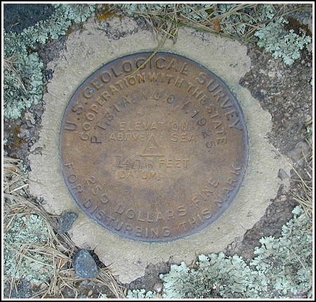
Spatial/elevation data
| Coordinates | N 41.372266° W 75.12675° |
| Elevation | 1415.94 ft. |
| Location | Pennsylvania
Pike County Promised Land Quad |
Mark description
| Type | Bench Mark Disk |
| Setting | Boulder |
| Monumented | 1925 by USGS |
| Description (NGS) | NGS Datasheet |
NGS recovery information
Descriptive text
Recovered in good condition as described. The church is located at the intersection of PA Route 402 and S.R. 4004 (Blooming Grove Road). Handheld GPS coordinates for the bench mark are 41 22 20.2(N) 075 07 36.3(W).Narrative and photographs
This benchmark was on the way home from the “Delaware Rock Show” cache, and I had a feeling it would be an easy one. I found it just as described and in very good condition. It’s located on top of the only real boulder in the church yard, right down by the road. You can’t miss it. A church service was beginning as I arrived and I got a few strange looks, but no one bothered me.


(Recovered on August 10, 2003)
This vertical control station is located on the top surface of a large outcropping boulder close to the road in the front lawn of Good Shepard Church on Gumbletown Road, east of the intersection of Rt. 402. The historical description leads reliably to the station. At the station mark a Garmin GPSmap76 receiver indicated 36.8 feet from the scaled NGS datasheet coordinates. The disk is in very good condition and the stamped designation is legible, but it does not precisely match the official designation on the datasheet. Instead, it reads: P.T. STA. NO. 6Y. 1925. ~Rich in NEPA~


