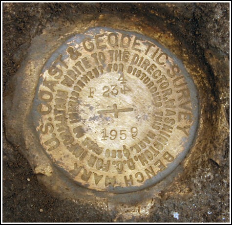
F 234 (LY1186)
F 234
Spatial/elevation data
| Coordinates | N 41.35145° W 75.311166° |
| Elevation | 1455.88 ft. |
| Location | Pennsylvania
Pike County Newfoundland Quad |
Mark description
| Type | Bench Mark Disk |
| Setting | Rock Outcrop |
| Monumented | 1959 by NGS |
| Description (NGS) | NGS Datasheet |
NGS recovery information
Descriptive text
Recovered in good condition. The station is located approximately 250 feet south along School House Road (T 384) from the T-intersection of School House Road and Ledgedale Road (T 380), set in an outcropping rock shelf as described. The mark is approximately 41 feet northwest of the centerline of School House Road. The stump of the 18 inch maple tree remains. The aspen tree and fence line no longer exist. Autonomous (non-corrected) handheld GPS coordinates for the station are 41 21 5.22(N) 075 18 40.20(W).Narrative and photographs
After geocaching and hiking nearby, Rich and I thought we’d try to track down a few benchmarks. The description led us to believe that this one would be an easy find, but we had trouble finding the “shelf”. It wasn’t obvious from the road as we had expected it would be. After poking around for a few minutes, we tried a different approach. Rich paced off approximately 250 feet along School House Road from its intersection with Ledgedale Road. We then turned 90° to the right, walked into the woods and immediately saw the shelf right in front of us. As described, the mark is set in the top of the east end of the shelf. The mark is in good condition, and we noted that the “4” was originally stamped sideways and then was stamped above in the correct orientation. We were unable to find any evidence of the large-tooth aspen or the fenceline, and only the stump of the maple remains. The description lacks a measurement from the centerline of School House Road; we measured this distance as 41 feet, at 330° magnetic.


Recovered in good condition.
This second order vertical control station is set in the top of the narrow exposed section of an outcropping rock ledge, about 250 feet south along School House Road (T384) from a T-intersection with Ledgedale Road (T380). The historical description was sufficiently helpful in finding the station, but a number of reference items have changed. Neither the large tooth aspen nor the fence line exist any longer. It appears that only the rotting stump of the 18-inch maple remains. The station is 41 feet northwest of the centerline of School House Road. At the station a Garmin GPSmap76 receiver with remote active antenna was used to record autonomous (non-corrected) coordinates which were roughly 310 feet from the scaled coordinates listed in the NGS datasheet. The mark is exposed, in good condition, and the stamped designation is legible.


