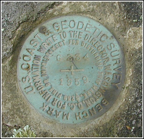
G 234 (LY1185)
G 234
Spatial/elevation data
| Coordinates | N 41.348966° W 75.30715° |
| Elevation | 1570.70 ft. |
| Location | Pennsylvania
Pike County Newfoundland Quad |
Mark description
| Type | Bench Mark Disk |
| Setting | Boulder |
| Monumented | 1959 by NGS |
| Description (NGS) | NGS Datasheet |
NGS recovery information
Descriptive text
Recovered in good condition. The station is set in the top of a boulder as described and is located 43 feet east of PPL powerpole number 67057-N44025-13664, 110.5 feet north-northeast of BT CO. utility pole A-7-1, and 42 feet south-southwest of the center of a sign “PP&L Ledgedale Recreation & Camping Area”. Handheld GPS WAAS-corrected coordinates for the station are 41 20 56.28(N) 075 18 25.74(W).Narrative and photographs
A fantastic morning of geocaching at Ledgedale was followed by two benchmark recoveries. This was the second, and it was a much easier find than F 234. The triangle-shaped boulder is quite distinctive, and we basically walked right up to it—it helped, too, that the scaled coordinates were only about 35 feet from the coordinates we recorded on the spot. The boulder is one of several on an outcrop opposite the intersection of Route 507 and Ledgedale Road. As Rich notes in his recovery, some of the reference objects have changed, specifically the utility pole numbers. The disk is in very good condition with legible stamping and the setting seems stable.


N 41° 20.938’ W 075° 18.429’
Recovered in good condition.
This second order vertical control station is set in the top of a large flat exposed boulder. The historical description was sufficiently helpful in finding the station but some of the reference items have changed. The station is 43 feet east of PP&LCo powerpole number 67057-N44025-13664, 110½ feet north-northeast of BTCo utility pole A-7-1, and 42 feet south-southwest from the center of the “PP&L Ledgedale Recreation & Camping Area” sign. At the station a Garmin GPSmap76 receiver with remote active antenna was used to record WAAS-corrected coordinates which were 35.5 feet from the scaled coordinates listed in the NGS datasheet. The mark is well exposed, in good condition, and the stamped designation is legible.
~Rich in NEPA~


