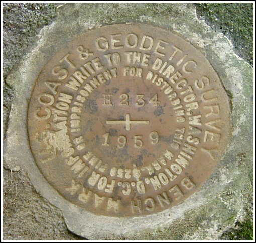
H 234 (LY1180)
H 234
Spatial/elevation data
| Coordinates | N 41.34175° W 75.298183° |
| Elevation | 1553.84 ft. |
| Location | Pennsylvania
Pike County Newfoundland Quad |
Mark description
| Type | Bench Mark Disk |
| Setting | Boulder |
| Monumented | 1959 by NGS |
| Description (NGS) | NGS Datasheet |
NGS recovery information
Descriptive text
Station mark recovered in good condition. The mark is located near the T-intersection of Beaver Dam Road (T 389) and Bartleson Road (T 355). It is set in a boulder as described, approximately 72.3 feet (22 meters) west-southwest of the centerline of Beaver Dam Road and 71 feet (21.7 meters) west-northwest of telephone pole BT Co 19/A-7/A-8. Autonomous (non-corrected) handheld GPS coordinates for the station are 41 20 30.30(N) 075 17 53.46(W).Narrative and photographs
We had achieved our main goal for the day—a successful recovery of nearby triangulation station PINE—and we stopped for a few simple benchmarks on our way back to the Interstate. This mark was a relatively easy find, though we stood on top of it for a minute before we noticed it was at our feet. While we photographed the mark and checked the reference objects, a man who’d been using a Bobcat nearby to clear brush approached Rich to ask what we were doing on his land. He was friendly and gave us no trouble, and seemed at least mildly interested in our explanation of benchmarks. He was surprised that he had never noticed the mark, having owned the land for years. Eventually the man went about his business and we finished up our measurements. We measured a slightly different distance from the centerline of Beaver Dam Road (noted in the official recovery) and took a measurement from the nearest pole (BT Co. 19/A-7/A-8) because the one mentioned in the 1959 description no longer exists (the landowner confirmed that the poles were replaced several years ago). We did not locate the trees that were originally used as reference objects. The disk is in good condition with legible stamping, and was found set in the boulder as described in the 1959 recovery note.
Those who seek this mark in the future should be aware that the mark is located on private—though non-posted—property owned by Mr. Wayne Croft, who lives in the house on the adjacent lot.


Recovered in good condition.
This second order vertical control station was found as described. The historical directions are still usable, except that the road is T-389 (not T-350) and named Beaver Dam Road, which intersects with Bartleson Road (T-355). The station is roughly 72.3 feet (22 meters) west-southwest of the centerline of the road, and 71 feet (21.7 meters) west-northwest of powerpole BTCo. #19/A-7/A-8. At the station a Garmin GPSmap76 receiver with remote active antenna was used to record autonomous (non-corrected) coordinates which were roughly 47.5 feet from the scaled coordinates listed in the NGS datasheet. The mark is well exposed, in good condition, and the stamped designation is legible.
~Rich in NEPA~


