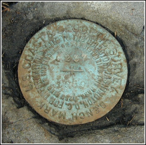
G 237
Spatial/elevation data
| Coordinates | N 41.371567° W 75.10525° |
| Elevation | 1463.58 ft. |
| Location | Pennsylvania
Pike County Pecks Pond Quad |
Mark description
| Type | Bench Mark Disk |
| Setting | Boulder |
| Monumented | 1959 by NGS |
| Description (NGS) | NGS Datasheet |
NGS recovery information
Descriptive text
Recovered in good condition on Blooming Grove Hunting and Fishing Club property. The mark is about 31.5 feet northwest of the centerline of Club Road and is approximately level with the road.Narrative and photographs
A successful recovery of nearby triangulation station BLOOMING was followed by a quick search for this mark just alongside Club Road, the main entranceway to this section of Blooming Grove Hunting and Fishing Club property. The description’s statement that the station is “east of the centerline of the gate to the entrance of the club” is incorrect. The station is actually northwest of the centerline of Club Road; we measured the distance at 31.5 ft. The mark is approximately level with the road.


N 41° 22.290’ W 075° 06.316’
Recovered in good condition.
This second order vertical control station is set in the top of an outcropping boulder on property owned by the Blooming Grove Hunting & Fishing Club. The historical description errs when it states the station is east of the gate at the entrance to the club. It is 31½ feet northwest of the centerline of Club Road and about level with the pavement. There is a small stone pavilion at the intersection of Blooming Grove Road and Club Road. At the station a Garmin GPSmap76 receiver with remote active antenna was used to record WAAS-corrected coordinates which were 84.5 feet from the scaled coordinates listed in the NGS datasheet. The mark is well exposed, in good condition, and the stamped designation is legible.


