21 S 1 (KV7125)
21 S 1
Spatial/elevation data
| Coordinates | N 40.91735° W 74.812233° |
| Elevation | 775 ft. |
| Location | New Jersey
Warren County Tranquility Quad |
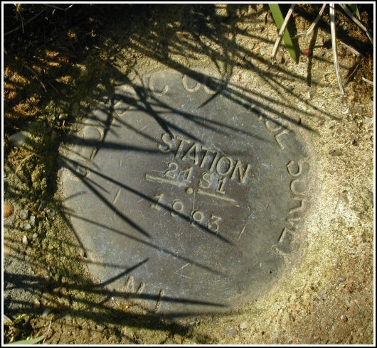
Mark description
| Type | Geodetic Control Survey Disk |
| Setting | Round Concrete Monument |
| Monumented | 1993 by New Jersey Geodetic Survey |
| Description (NGS) | NGS Datasheet |
Narrative and photographs
(What a hoot!) After a day of biking with friends at a nearby state park, Rich and I decided we had enough energy left to attempt to locate this marker. No signs warned us not to enter the area, though our choice of a parking spot may have been somewhat risky. Fortunately there were no goofy cops around to bother us, and we were left in peace to enjoy the sights and sounds of traffic rushing by below us on Route 80. We climbed to the summit of this landscaped area (it’s not as dramatic as it sounds) and located the mark easily, mostly due to the presence of a witness post less than two feet to the south. A mat of soil and grass is already encroaching on the mark, but it’s in good condition and the stamping can be read. The description is accurate.


While returning from a mountain biking expedition in the south section of Allamuchy Mountain S.P. it was a relatively easy process to stop along the curve of the entrance ramp just before getting onto I-80 west and look for this horizontal control station. The historic description leads reliably to the mark and there is even a surveyor’s stake with flagging to indicate the immediate location. At the station mark my Garmin GPSmap76 receiver indicated 18.8 feet from the posted coordinates. The disk is in very good condition and the stamped designation is quite legible. ~Rich in NEPA~


