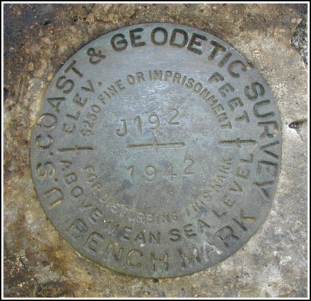
J 192 (KV2752)
J 192
Spatial/elevation data
| Coordinates | N 40.757833° W 75.7722° |
| Elevation | 567.12 ft. |
| Location | Pennsylvania
Schuylkill County Nesquehoning Quad |
Mark description
| Type | Bench Mark Disk |
| Setting | Boulder |
| Monumented | 1942 by NGS |
| Description (NGS) | NGS Datasheet |
Narrative and photographs
While in the area for some geocaching (and a little “vacation”!) Rich and I had some time left over to hunt for this benchmark. Expecting a railroad crossing, we were surprised when we arrived to find that the area is now heavily wooded and no rails exist. We were able to make out the railbeds but both the north and south tracks are no longer in place. After estimating the distances from the railbeds and Stone Mountain Road and checking several large boulders in the area, we zeroed in on the correct boulder and scraped the surface clean of moss and ants to reveal the disk. It’s in excellent condition with legible stamping.

N 40° 45.478’ W 075° 46.352’
This second order vertical control station is located on the top surface of a large outcropping boulder in a wooded area on the west side of Stone Mountain Road. The historical description leads reliably to the station, but the railroad tracks no longer exist. Dim remnants of the lines of the former railbeds (north tracks and south tracks) are discernable through the trees and brush and appear to be the appropriate distance apart, with the station between them. The mark was concealed by a mat of dirt, moss and duff. The surface of the rock was scraped clean and the disk is now well exposed. At the station a Garmin GPSmap76 receiver with remote active antenna indicated 110 feet from the scaled NGS datasheet coordinates (signal reception was poor within the wooded area). The disk is in excellent condition and the stamped designation is legible. ~Rich in NEPA~


