N 191 (KV2637)
N 191
Spatial/elevation data
| Coordinates | N 40.75675° W 75.748416° |
| Elevation | 692.04 ft. |
| Location | Pennsylvania
Carbon County Lehighton Quad |
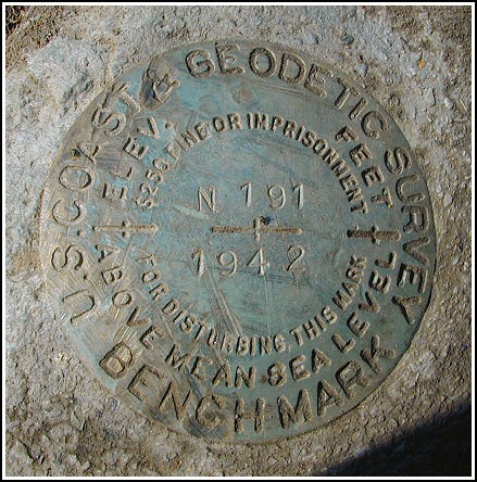
Mark description
| Type | Bench Mark Disk |
| Setting | Square Concrete Monument |
| Monumented | 1942 by NGS |
| Description (NGS) | NGS Datasheet |
Narrative and photographs
Armed with the significant benchmark hunting experience I’ve gained over the past year, I thought it would be worthwhile to give this one another try while in the area for a day of geocaching with Rich. The description (along with plenty of careful searching and a little luck) was enough to allow us to locate the mark. Except for the witness post and the barn lot fence, all landmarks in the description are still in place. The “Y road” mentioned in the description refers to the intersection of Germans Road and Bake Oven Road, which lies just to the southwest of the mark. The concrete monument has been disturbed, but aside from a few scratches the disk itself is in good condition and the stamping is clearly legible.


This second order vertical control station is set in the top of a concrete monument flush with the ground roughly 4 feet from the northwest edge of the pavement of Germans Road and northeast of the intersection with Bake Oven Road. The historical description leads reliably to the station and except for the white witness post, the items referred to (walnut tree, barn, etc.) still exist. The mark was mostly concealed by dirt and grass. The surface of the monument and the surrounding area was cleared and the disk is now exposed. At the station a Garmin GPSmap76 receiver with remote active antenna indicated 38 feet from the scaled NGS datasheet coordinates. The setting has obviously been disturbed, perhaps struck by a snowplow or farm equipment, and the monument is now inclined to a significant degree from vertical. The disk itself is in good condition and the stamped designation is legible. ~Rich in NEPA~


