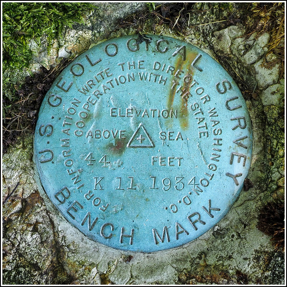
K 11
Spatial/elevation data
| Coordinates | N 44.430816° W 68.286783° |
| Elevation | 43.666 ft. |
| Location | Maine
Hancock County Salsbury Cove Quad |
Mark description
| Type | Bench Mark Disk |
| Setting | Rock Outcrop |
| Monumented | 1934 by USGS |
| Description (USGS) | Salisbury Cove Post Office, 300 ft. W. of, in ledge outcrop, 50 ft. N. of rd. and 20 ft. E. of parsonage driveway; standard disk stamped “K 11 1934” “T.B.M. 43.7” on telephone pole Revised desc. - At church parsonage; 57 ft east of SE corner of parsonage porch; 59 ft SE of NE corner of parsonage stone foundation; 65.5 ft north centerline of road; 60.2 ft north of power pole #225; standard tablet set in top of a large ledge; stamped “K 11 1934” |
Narrative and photographs
K 11 is quite an intriguing mark. Both the topo map coordinates and the MaineDOT coordinates are off significantly. We actually spotted a likely ledge on Street View last winter when we were researching marks to target during this year’s trip to Maine, but we almost wrote it off because usually the topo map coordinates are much more accurate. In this case, if the ledge were the correct location, the topo map coordinates would have been off by 125 feet or so.
When we arrived at the site, though, I could tell that there was no large ledge anywhere the topo coordinates, so Rich parked and I checked the large ledge we’d spotted on Street View anyway. I immediately spotted the marker on top! So cool. I’m still trying to figure out which building was the parsonage, if it still exists, and what the discrepancy is with the topo map coordinates. But it was an exciting find, and it’s always fun when there is more research to do.
So far I haven’t been able to find any information about the parsonage. I searched for it on old Sanborn maps, which do not cover this particular spot, and old town maps, which also don’t show anything relevant. The adjacent house to the west, 143 Old Bar Harbor Road, seems a likely candidate because it was built in 1900 (according to a plaque on the front of the house) and it basically matches the dimensions given in the description.
The disk is in very good condition, and the ledge is solid and doesn’t appear in any danger of being damaged or compromised. The ledge is located between #137 and #144 Old Bar Harbor Road, just west of the Edgewater Motel, Cottages, and Suites.


