6 JPN
Spatial/elevation data
| Coordinates | N 41.074883° W 75.915633° |
| Elevation | 1068.028 ft. |
| Location | Pennsylvania
Luzerne County Wilkes-Barre Quad |
Mark description
| Type | Bench Mark Disk |
| Setting | Boulder |
| Monumented | 1942 by USGS |
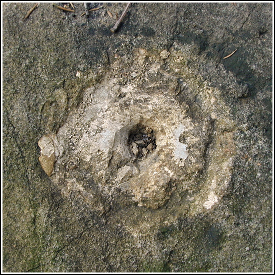
| Description (USGS) | Rita, 2.2 mi S., thence 2.1 mi SW. of; 120 ft N. of rd.; 39 ft NW. of NW. corner of small cabin enclosed by wire fence on the farm of William Bozaczlo (Bozalzie in traverse description); in large boulder at N. edge of wire enclosure; about 1 ft. above level of ground; standard tablet stamped “6 JPN 1942 1058” |
USGS recovery information
View reportNarrative and photographs
Rich and I had this survey mark in mind when we decided to travel to Nescopeck State Park for some geocaching and squirrel hunting on this very cold Tuesday morning. We were very close to the parking area for the GODZILLA! geocache when Rich happened to look into the woods and noticed concrete steps standing among the trees, maybe 100 feet back from the edge of the road. I still don’t know how he managed to look in exactly the right spot as we drove by. I had a hard time spotting them when I knew where to look! But somehow he did see them, and we kept them in mind to explore after finding the geocache, if there was time.
We were warm enough (just barely!) after our hike up and back down Mount Yeager, so we took the quarter-mile walk from the parking area toward the orphan steps. It soon became apparent where the old cabin had stood. We followed the directions on the USGS datasheet and very easily spotted the large boulder. I was excited, but that feeling didn’t last. When we got closer we could see that the mark was gone; from all appearances, it was long gone. The disk and stem were nowhere to be found although the impression of the marker in the rock was quite clear. We found no trace of the old wire fence. Our only slight disappointment of the day, this was nevertheless a neat discovery and, although it’s not the kind of report I prefer to make, we can still report our findings to USGS.

