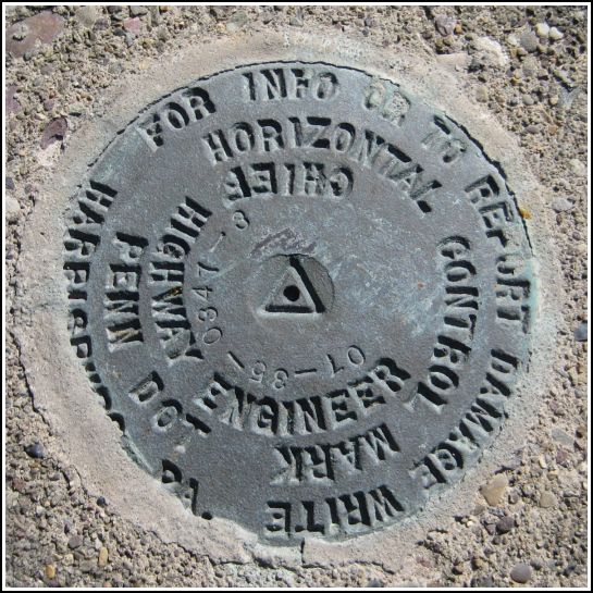
07-35-0347-3
07-35-0347-3
Spatial/elevation data
| Coordinates | N 41.492617° W 75.6194° |
| Elevation | Unknown |
| Location | Pennsylvania
Lackawanna County Olyphant Quad |
Mark description
| Type | Horizontal Control Disk |
| Setting | Concrete Bridge Sidewall |
| Monumented | Unknown by PennDOT |
| Description (PennDOT) | Unavailable. |
Narrative and photographs
Last week while I was on my way to Wegmans, I happened to look to my right as I passed over a small culvert. I saw a disk! There is an old stone retaining wall along much of this section of Route 347, and I had occasionally wondered whether a benchmark might be set somewhere along its length. I still haven’t seen anything on the wall itself, but I was very excited to see this disk that I had never noticed before. Research indicated no USGS marks in the immediate area, so I assumed that it was another PennDOT mark, but I had to find out for sure.
Today I parked at St. Michael’s cemetery and slid down the wooded embankment toward the highway. I was able to stay behind the guard rail and walk along the top of the retaining wall for several yards until I was next to the mark. I discovered that it is indeed another PennDOT mark. It’s in an awkward location, so it would be interesting to see how this mark is actually used.
When I checked out the photos at home, I noticed something else that somehow never occurred to me before—the third section of the designation is the route number (in this case, 347). This holds true for the other stamped PennDOT marks I’ve found as well. I had suspected for some time that the first two digits refer to the year the mark was set (or stamped) and this seems to hold true. I also suspect that the fourth number is just a sequential identifier (in this case, indicating that this mark is third in a particular line—maybe a line along Route 347). I have no hypothesis for the meaning of the second two digits (35 in this and other cases, and 36 for some other local marks).

