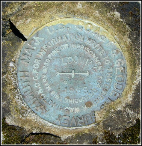
BLOOMING AZ MK (LY1221)
Recovered in Good Condition on April 24, 2004
Spatial/elevation data
| Coordinates | N 41.350666° W 75.131433° |
| Elevation | 1610.51 ft. |
| Location | Pennsylvania
Pike County Promised Land Quad |
Mark description
| Type | Azimuth Mark Disk |
| Setting | Rock Outcrop |
| Monumented | 1959 by NGS |
| Description (NGS) | NGS Datasheet |
NGS recovery information
Descriptive text
Recovered in good condition. The 8-inch triangular blazed maple tree was not found. Handheld GPS WAAS-corrected coordinates for the azimuth mark are 41 21 2.46(N) 075 07 53.16(W). The mark is located on the property of the Blooming Grove Hunting and Fishing Club. Contact information - Scott F. Savini, General Manager, HC 8 Box 8066, Hawley, PA 18428, 570-775-7371.Narrative and photographs
For more information about this reference mark, see its parent mark BLOOMING.


Recovered in good condition.
Azimuth mark BLOOMING is set in the top of an outcropping boulder about 20 feet northeast from the centerline of a private and gated track road, about 1 foot above ground level, on property owned by the Blooming Grove Hunting & Fishing Club. The blazed maple tree near the mark no longer exists.


