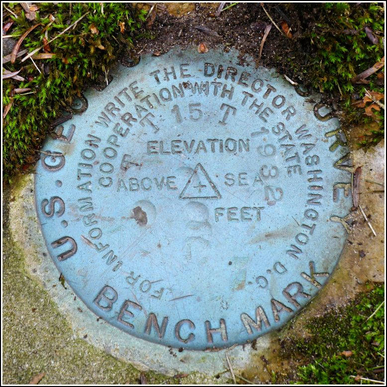
TT 15 T
TT 15 T
Spatial/elevation data
| Coordinates | N 41.63594° W 75.38209° |
| Elevation | 1478.003 ft. |
| Location | Pennsylvania
Wayne County Forest City Quad |
Mark description
| Type | Bench Mark Disk | ||||||
| Setting | Boulder | ||||||
| Monumented | 1932 by USGS | ||||||
| Description (USGS) | Coggins School, 1.5 mi N. of; 0.3 mi S. of White Oak Pond; 1.4 mi NE. of N.-S. turnpike; 137 ft NE. of fork of rd. SW. to N.-S. turnpike; at edge of timber; in large boulder; standard tablet stamped “TT STA NO 15 T 1932” (Tied by NGS, 1942) Aldenville, 1.2 mi W. of, thence 0.4 mi S.; 1.5 mi N. of Coggins School; 0.5 mi S. of White Oak Pond; 137 ft NE. of rd. forks SW.; at edge of timber; in large boulder; standard tablet stamped “TT 15 T 1932”
|
Narrative and photographs
Rich and I probably relied too much on what we thought we saw on Google Street View when we were investigating this mark from home. We expected the disk to be on one of the large boulders or outcrops that were apparent in the Street View. We also expected to encounter poison ivy and heavy vegetation at the site. We didn’t expect that the boulder would be far enough from the road that it was actually on the property of a log cabin house set back in the woods. When we realized this, and then saw a man walking around in the yard, we decided to take the opportunity to approach the house and see if the man knew anything about the mark. Perhaps it was on one of the large boulders lining his driveway?
Dad and I approached the man while his friendly but loud dogs serenaded us continually from behind the windows of the house. “Yes,” the man said when we asked him if he knew anything about a survey disk on his property, “it’s right over there.” And it was right near where Dad was standing, set into a large, deeply embedded boulder. Although the other, larger boulders lining the driveway had been brought over from the wooded area adjacent to the road, the boulder holding the disk had not been disturbed.
We told the man more about his mark and about the purpose of survey marks in general, and then I documented the find while Dad chatted with him for a few more minutes. We didn’t get the man’s name, but he said that the previous owner of the property, John DeCarlo, had pointed out the survey mark to him when they were in the process of selling the property. He had always protected it (it’s now a feature, intentionally or not, in a little rock garden) but didn’t know its exact purpose. I was sure to let him know just how lucky he is to have such a special piece of history on his property!
The bench mark disk is in good condition in an embedded boulder. It is approximately 140 feet northeast of the T-intersection of Elk Lake Drive and Cross Road.

