RGH 17
RGH 17
Spatial/elevation data
| Coordinates | N 41.41005° W 75.592583° |
| Elevation | 1463.88 ft. |
| Location | Pennsylvania
Lackawanna County Olyphant Quad |
Mark description
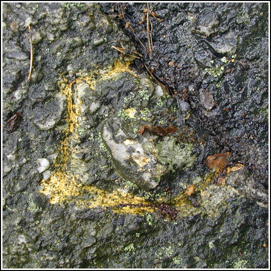
| Type | Chiseled Square |
| Setting | Rock Outcrop |
| Monumented | 1997 by PennDOT |
| Description (PennDOT) | To reach bench mark RGH 17 from the Dunmore branch of the Scranton post office, follow Harper Street east for 0.3 km (0.2 mi) to E. Drinker Street (Rt. 435). Proceed on E. Drinker St for 2.4 km (1.5 mi) to Tigue Street. Take Tigue St until it ends, approximately 0.4 km (0.25 mi) at a gravel road. Follow the gravel road up the mountain to PADOT waste area 1 approximately 0.9 km (0.6 mi). The bench mark is located in a saddle at the end of two trails. Please see: RGH 17. |
Narrative and photographs
This Wednesday morning started out damp but warm. Rich just finished this week’s work rotation at 6:00am, and despite his sleepiness was eager to spend some time outdoors first thing. We decided to head up to Moosic Mountain, approaching the trails from the southwest this time, behind the Holiday Inn and near ROAR 2. This would allow us to search for RGH 17, as well as RGH 18, RGH 24, and RGH 19 if time allowed.
We parked along the access road and hiked toward the coordinates through fragrant fields of white and lilac crown vetch. Nearing the coordinates we spotted the configuration of trails that matched our datasheet diagram, and a minute later Rich found the chiseled mark on a rock nearly flush with the ground. It is in fair shape, outlined in yellow paint, and the rock is embedded and doesn’t appear to have moved. As described, it sits at the northeast corner of the intersection of the main trail (which heads east at this point) and a narrower side trail leading roughly north.
While I documented the site with photos, Rich wandered through the woods and followed a squirrel for a few minutes. We then hiked on eastward along the main trail toward RGH 18.


