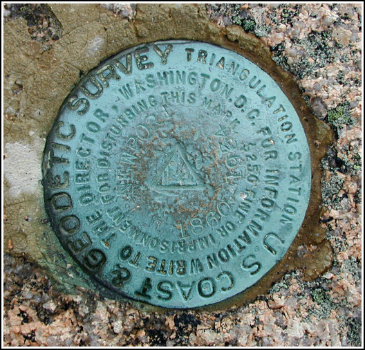
NEWPORT (PE1780)
NEWPORT
Spatial/elevation data
| Coordinates | N 44.350733° W 68.194° |
| Elevation | 1056 ft. |
| Location | Maine
Hancock County Seal Harbor Quad |
Mark description
| Type | Triangulation Station Disk |
| Setting | Bedrock |
| Monumented | 1860 by NGS |
| Description (NGS) | NGS Datasheet |
NGS recovery information
Descriptive text
The station mark and reference marks 1 and 2 were recovered in good condition.Narrative and photographs
What an adventure! After a long, hot, wonderful morning of sunrise-viewing, seal-watching, benchmark hunting and hiking, Rich and I decided we’d enjoy an afternoon hike up on Champlain Mountain. As the Precipice Trail was closed this early in the season (to my great disappointment), we decided to hike the Bear Brook Trail instead. The hike began in the same kinds of conditions we’d experienced all morning—sunny and humid—but halfway up, we heard something, turned, and saw a thunderstorm coming at us straight across the bay. Yikes! We had little time to do anything but cover ourselves, crouch down, and wait. It was frightening, exhilarating, and hilarious all at once. The storm passed directly over and the thunder was amazing, but we didn’t experience any nearby lightning strikes. The rain was pounding us like handfuls of stones; I could hardly believe it was simply rain and not hail. After the storm passed (and after Rich took a few wacky photos of me wrapped up in my emergency poncho), we set out again for the top of the mountain. And of course, it showered once or twice more. This time we got soaked, but didn’t mind as the air was still warm. We found the station disk and both reference marks easily, and they’re all in good condition.
On our way back down the trail, we spotted another disk stamped JDR/USA.


(Recovered on September 5, 2002)
N 44° 21.044’ W 068° 11.643’
While vacationing on M.D.I. I decided to search for a few local benchmarks. I drove out along the Park Loop Road from Bar Harbor and parked in the Precipice parking lot, then hiked up the Precipice Trail to the summit of Champlain Mountain and easily found two of the three marks in this set. (I was unaware of the third mark when I made this find. This mark does not show up in either a Zip Code or a Nearest Benchmark search!) At the triangulation station my Garmin GPSmap76 receiver indicated 13 feet from the posted coordinates for the station. These two discs were quite visible and are in excellent condition. I’ve hiked this trail many times. ~Rich in NEPA~


| Designation | Status | Condition | Image |
|---|---|---|---|
| NEWPORT RM 1 | Recovered | Good |
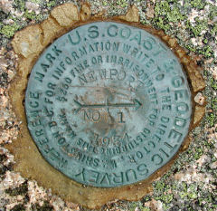
|
| NEWPORT RM 2 | Recovered | Good |
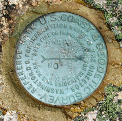
|