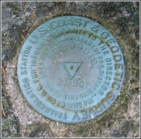
SCHOODIC RESET (PE1769)
SCHOODIC RESET
Spatial/elevation data
| Coordinates | N 44.35073° W 68.05295° |
| Elevation | 440 ft. |
| Location | Maine
Hancock County Schoodic Head Quad |
Mark description
| Type | Triangulation Station Disk |
| Setting | Rock Outcrop |
| Monumented | 1860 by NGS |
| Description (NGS) | NGS Datasheet |
NGS recovery information
Descriptive text
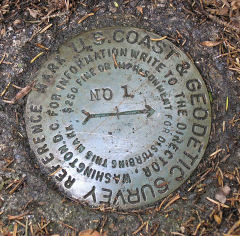
The station and all three reference marks were recovered in good condition. The 1971 station description and to-reach remain accurate. Autonomous (non-corrected) handheld GPS coordinates for RM 1 are 44 21 2.4(N) 068 03 10.9(W). Autonomous (non-corrected) handheld GPS coordinates for RM 2 are 44 21 2.2(N) 068 03 10.3(W).Narrative and photographs
Eager to explore someplace a little different for the day, we left MDI and headed for Schoodic Peninsula on this foggy Monday. After a leisurely several hours’ drive around the point, stopping many times along the way to take photos, climb on the rocks and poke around in the bunchberries, we decided to hike to the summit of Schoodic Head. (It was no coincidence that a tri-station and three reference marks are located there, to Aaron’s dismay.) We began from the Blueberry Hill parking area and took the open, relatively level Alder Trail northwest to then Schoodic Head trail, which becomes narrower, rocky and steep as it winds northeast toward the summit.
We first encountered RM 2 as we made our way to the station. Then the station disk was found with ease, as expected. Finding RM 1 was a very difficult challenge and it was the reason our recovery took the better part of an hour. This reference mark was buried beneath a layer of soil and debris, and a rock partially covered the location as well. The use of compass and measuring tape was required, and even then, finding the disk was difficult.
While Rich worked on his photographs, I jogged north along the ledges toward RM 3 (PE1772), which is quite a distance from the station and the other reference marks. RM 3 is situated on a ledge with a clear view (on a clear day) west over Winter Harbor. This would be a magical spot for a picnic lunch! We found all marks to be in good condition, and the datasheet description does not require any changes.

 found RM 1.")
| Designation | Status | Condition | Image |
|---|---|---|---|
| SCHOODIC RESET RM 1 | Recovered | Good |
|
| SCHOODIC RESET RM 2 | Recovered | Good |
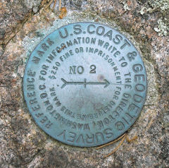
|
| SCHOODIC RM 3 | Recovered | Good |
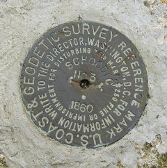
|