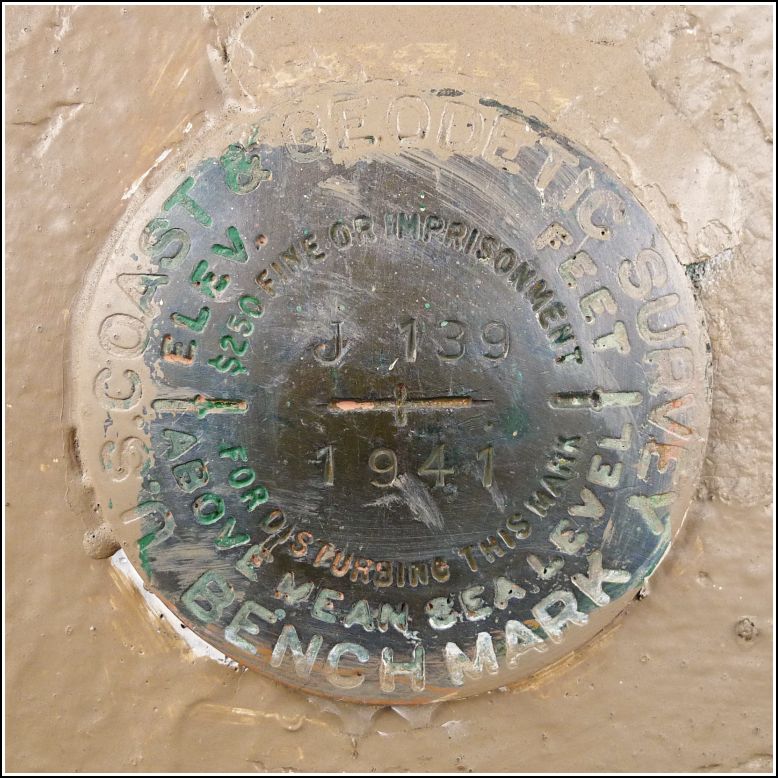
J 139 (NA1289)
J 139
Spatial/elevation data
| Coordinates | N 42.294555° W 75.480416° |
| Elevation | 1005.40 ft. |
| Location | New York
Chenango County Sidney Quad |
Mark description
| Type | Bench Mark Disk |
| Setting | Concrete Foundation |
| Monumented | 1941 by NGS |
| Description (NGS) | NGS Datasheet |
NGS recovery information
Descriptive text
Recovered in good condition. The bench mark is set vertically into the southwest wall of the building housing the Village of Bainbridge Offices. Handheld GPS coordinates for the bench mark are 42 17 40.4(N) 075 28 49.5(W).Narrative and photographs
When Rich and I first heard that we’d be traveling to Bainbridge with Dad this weekend, we conducted our usual research to check for nearby survey marks. This one looked like an easy, straightforward find set into a building with some interesting history, so we put it on our list. When we arrived at the site, we spotted the mark immediately, just to the left of the door and in excellent condition. Despite a sloppy paint job on the surrounding wall, the disk’s stamping is untouched and easy to read.
The building retains its railroad-station architecture from its days serving as the Delaware and Hudson freight depot, but it now houses the Village Offices—village clerk at the main door, and the police station in back. In an epic coincidence, perched in the window just above the mark was a gorgeous Thanksgiving cactus, one of my favorite plants, still blooming a bright magenta-purple.
However, not all days at this former freight depot were so pleasant.
On a cold January evening in 1966, a Delaware and Hudson freight train heading north from Binghamton derailed at this crossing. Forty-four hurtling boxcars tore through nearby homes, injuring several residents and killing two. According to an article in the Oneonta Star (January 8, 1966), the former freight depot suffered only minor damage, but the firehouse adjacent to the crossing was destroyed. Suppression of the fires resulting from the wreck required heroic efforts from five regional fire companies and everyone else in the village who was able to help. The tragedy of that evening changed the lives of many Bainbridge residents, and the memories continue to affect them.
For more, see: January 7, 1966: A Day Of Tragedy In Bainbridge, N.Y. and Oneonta Star, January 8, 1966.
The Tri-Town News from January 17, 2013 showed a graphic overhead view of the wreck and the horrifying destruction it caused, but that article is no longer available.


.")
